What happens now? (1994)
This is chapter 4.
Contents:
- Chapter 1: First Effort
- Chapter 2: Motorways
- Chapter 3: City Centre
- Chapter 4: Outcome
The Central Dublin Traffic Plan believed that, if it was delivered as instructed, it would work for everybody. It's easy to read through it and be taken in by its upbeat nature and vision.
Then you get to the costs.
Some IR£122 million (1973, approximately €1.9 billion in 2020) would be spent on major roads in Co. Dublin before a decent commuter network would come together. That figure excluded public transport, excluded new and existing ongoing maintenance costs, and even excluded most of the Inner Tangent. It simply wasn't possible.
It was worse than it sounded. The two traffic plans worked because the roads relied on each other. If you only built half the roads, you would get very few of the predicted benefits.
The Western Tangent, for example, was designed to be built "immediately". It was going to replace streets that were narrow and dangerous and it would provide a major new crossing of the Liffey. Yet the study established it was "very possible" that there wouldn't be enough money to start building a single part of it until 1991.
The problem with the vision of the Central Dublin Traffic Plan wasn't just that 1991, which was still 18 years away, was a long time to wait for road improvements. The problem was - as the study itself pointed out - by 1991 it was very likely that society would have changed and that a whole new outlook would be needed.
In chapter 3 we condescendingly described the plan as being "forward-thinking" because it remembered to think about pedestrians. Well the most forward-thinking part came in the summary: it suggested that by time Dublin was ready to act on the report, the report would be outdated and, in its own words, "shelved". It predicted its own cancellation.
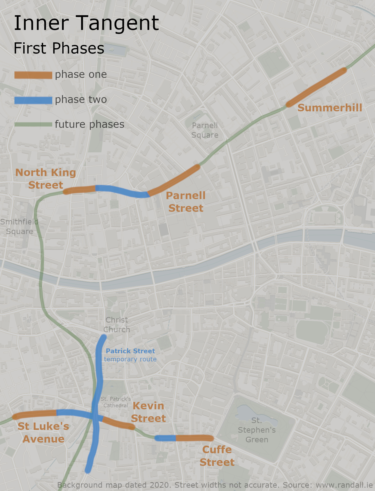
Phase It
The Central Dublin Traffic Plan still stood by its recommendations, and was now looking for a practical way they could be implemented.
On the east side of the city, it noted that a much smaller bridge could be built to keep traffic moving until the expensive Liffey Crossing was available. This opened in 1978 as Talbot Memorial Bridge. Its low capacity meant it could plug into the existing road network, without the need for expensive link roads to pick up traffic from the Canal and Fairview.
The easiest and highest priorities for the Northern and Southern Tangents (2.33 MB, tap to enlarge)
In chapter 3 we listed the areas along the Northern and Southern tangents where land was available and ready to use; these lists were another attempt by the study to prove that it hadn't been a total waste of time. It just left the delicate matter of the Western Tangent.
As the Western Tangent was going to be a wholly new road, you couldn't just build a tiny section of it. It needed somewhere to end.
The Central Dublin Traffic Plan proposed a five-stage plan. Phase one would involve widening the existing Patrick Street and Nicholas Street (N81), and then creating a one way system utilising Church Street and Greek Street/Winetavern Street. This would allow some cheap and immediate capacity and safety improvements that would keep things going until, in a series of sections, the new roads could be built.
The recommendations of the Central Dublin Traffic Plan were adopted as official policy by Dublin Corporation, with their main priority as far as the city centre was concerned being the start of phase one of the Western Tangent.
Too Much Too Soon
The Central Dublin Traffic Plan was badly received by the public. Predictably and understandably, people disliked everything about the new motorways and the Western Tangent.
With little money available to start work, Dublin Corporation certainly didn't have the money to start battling with residents.
The Central Dublin Traffic Plan had given the Liffey Crossing - the jewel in the crown of the new roads - an estimated opening date of 1979. By October 1976, no progress had been made.
The Central Dublin Traffic Plan was called into question. It was widely reported that it had been "shelved". In fact, what happened was the Dublin City and County Manager was asked to review the long list of objections.
In 1979 he proposed the following amendments:
The Royal Canal Motorway was "deferred".
The Fairview Spur was "postponed indefinitely".
The Airport Motorway and South Coast Motorway were to progress through the planning stages.
The ambitious Western Tangent was dropped and existing roads would be upgraded instead.
While these decisions might today sound like a step in the right direction, they did create an issue. None of the more progressive aspects of the Central Dublin Traffic Plan - including some ideas to transform O'Connell Street - could be introduced until there was somewhere for all the old traffic to go.
A new Dublin City Plan was put together. In May 1980, the Corporation announced that the Inner Tangent and Eastern Bypass would be dropped from this plan. In October 1980, they were put back in.
That was one way to wind your critics up. The revised projects were reduced in scale, but that technicality wouldn't matter if you lived on their route.
The new city plan was summarised with the words "less roads". While that might have been the way it was heading, we weren't really there yet.
A map of every incarnation of the Inner Tangent, with 1966 in blue, 1987 in orange and 2002 in red (1.49 MB, tap to enlarge)
The new vision for the Inner Tangent would now look more like it did in chapter 1. It would run along Patrick Street, Nicholas Street, High Street and Bridge Street. A second arm would use The Coombe, Pimlico, Thomas Court, Bridgefoot Street and Queen Street. This came to be known as the 'Outer Loop' or 'Outer Tangent'. The total cost for the two tangents was given as IR£40 million.
With the Liffey Crossing technically still in planning, the new Inner Tangent route was lacking on the eastern side. At Summerhill, it would simpy fizzle out, perhaps hoping that one day somebody would approve a road for it to connect to.
For residents in The Liberties, this was now the fourth time a new road had been proposed, and they were now understandably disillusioned with the authorities. Resistance to the new road was severe.
Various allegations were made about corruption within the Corporation, government and private developers. It's difficult to say how accurate these claims were. What does seem to be true is that Dublin Corporation had an unfortunate habit of purchasing buildings, allowing them to fall into ruin, and then arguing that they were an eyesore that should be demolished and - oh look at that - we could widen the road while we're at it.
This sort-of planning blight existed across Dublin's Inner City on an enormous scale. The city's busiest roads were a mess of derelict or decrepit buildings and decisive action was needed. Private owners were hardly going to purchase or invest in a building that was rumoured to be in the path of a new road.
One study described the number of buildings in Dublin with structual defects as "alarming", but blamed it on 50 years of cash-strapped city maintenance budgets. Whatever the reason, the 1980 City Plan highlighted whole districts on the western side of the city which it described as "obsolete", and therefore fair play for road construction.
On North King Street, everything on the left was bought up ready for road widening. Some of it has been replaced, some of it is still derelict 30 years later.
Meanwhile, there was an unexpected spanner in the works at Wood Quay. Here, close to the route of the Inner Tangent, Dublin Corporation had been trying to build their new offices. Their work was repeatedly delayed by several significant archaeological findings, prompting a large campaign for the work to be stopped.
That campaign wasn't successful, but it further increased tensions between residents and the Corporation's planners, and further damaged the Corporation's reputation for pushing through what it wanted.
In 1987, Dublin Corporation finalised another new development plan, backed by more external advice. The Corporation's enthusiasm for road building was clearly dwindling, and the Inner Tangent project was watered down yet again.
One of the issues at this stage was that Ireland's economy had been in a deep recession through much of the 1980s, which not only led to financial cutbacks, but also prompted planners to lose sight of what a healthy economy might look like. The high capacities dreamed of in the 1970s now seemed wasteful in a stagnating city. The 1973 oil crisis had further reduced the enthusiasm for car travel.
The consultants were severely critical of both the Inner Tangent and the way it had been handled, but their overall conclusion was that so much damage had been done that the job might as well be finished.
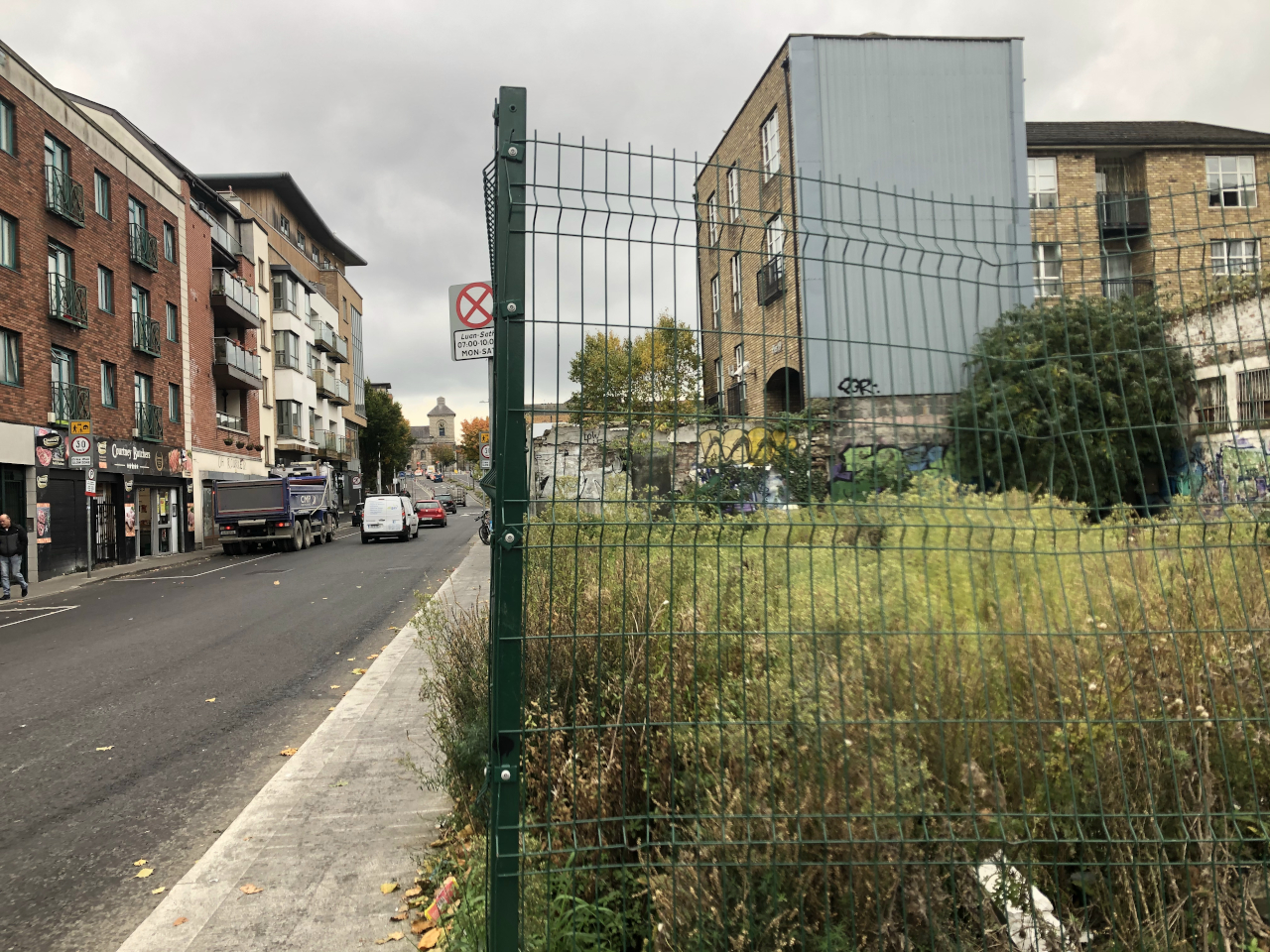
Crucially, it was decided that The Liberties was still intact enough to be worth preserving, and that the Outer Loop should be dropped. The only part of it that had been built was half of Bridgefoot Street, creating a great example of a big wide road that connects to nothing useful at either end that would now be preserved forever.
With The Liberties saved, the SICCDA launched a new project to invest in the area.
Above: The Bridgefoot Street 'road to nowhere' (taken just after it was made narrower in 2020).
Below: The scene on the other side of the wall.
30 years later, the land is mostly unused; you can see where space was made to widen the road.
Curiously the same was said about the plan to turn Temple Bar into a bus station, and CIÉ were urged to sell the land they had been holding on to for that project.
With regards to the Inner Tangent, a few short lengths that already had compulsory purchase orders in place were urged to be put into action. This included the short length of Cuffe Street. In other areas, especially in the Smithfield area, the plan was now to make do with the streets that were already there.
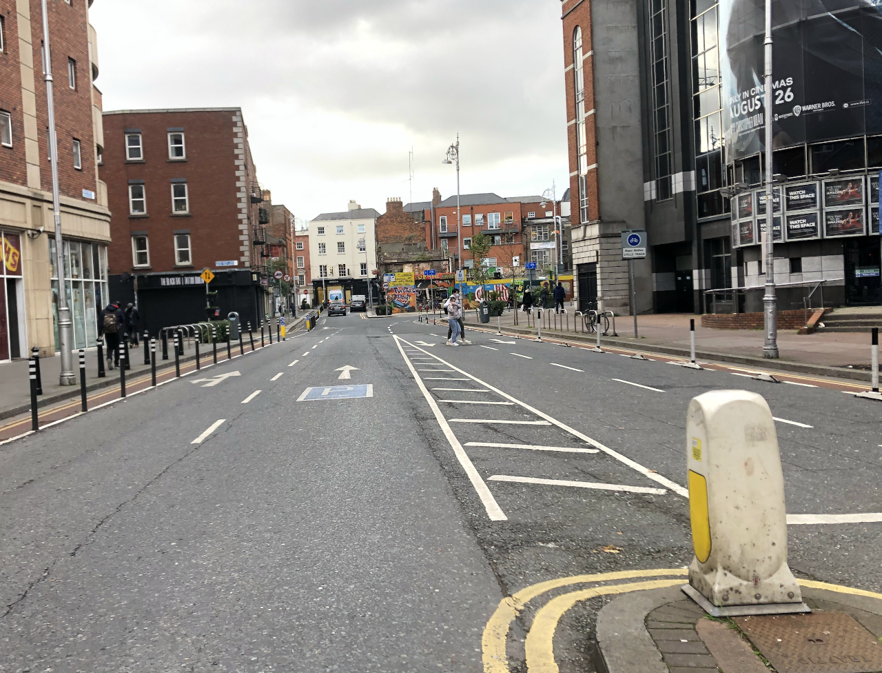
Parnell Street was one of those which was ready to go, but widening the streets at each end had now been removed from the programme. As a result, the whole thing feels half-hearted effort, being a short length of main road marooned by shopping streets. Where the old development plan had been summarised as "less roads", this one was "more environment" - though again that slogan may have been more of an aspiration than a policy.
The upgraded Parnell Street gives up as it reaches the failed western extension. Some of the buildings in the distance are still derelict.
The Inner Tangent was about to lose its fight, but it would win its last battle. When the consultants argued that "the damage had already been done", they were almost-certainly referring to the notorious N81 corridor: Clanbrassil Street, New Street, Patrick Street, Nicholas Street and Cork Street/St Luke's Avenue; all of which were notorious for their dereliction and fed up neighbours.
Whereas other parts of the Inner Tangent were in the city centre and arguably not a place you want to be encouraging traffic anyway, those five streets formed a key route into the city and there were no obvious alternative routes available. They were also some of the narrowest main roads.
To make matters worse, like a lot of European new towns, the economy of Tallaght was struggling to take off. No funding had been made available for any trams or busways. Tallaght was dependent on a bog standard bus route - and those buses were getting stuck in the narrow, twisty and congested Clanbrassil Street.
Widening this road had been planned as far back as 1953. Under the Western Tangent plan just 16 years previous, this was supposed to be the widest and most urgently-needed road in Dublin, that would take a new alignment all the way down to Harold's Cross. It was inevitable that something was going to be built here.
Once that road had been widened, there was no more case to be made for road building in Dublin. The Corporation had been responsible for so much tension and outcry that any further proposals would be aggressively scrutinised, and nobody had the energy to push through with them.
Cork Street was extended onto St Luke's Avenue through this building, leaving a very obvious scar.
In particular, the new activist group Students Against the Destruction of Dublin had pledged to fight new road proposals, and influenced the city's development plan. The President of the Institute of Architects called on Dublin Corporation to start reinstating some of the streetscape they had been destroying. An Taisce (The National Trust for Ireland) had called for all major road schemes in Dublin to be called.
The Inner Tangent was never mentioned in the 1990s, except in frustration. Though it did return.
In 2002, Dublin City Council designated an Inner Orbital Route, created out of existing roads. This was a new brand for what was the last version of the Inner Tangent, with a little inspiration from the very first plan. It wasn't so much a dastardly effort to cover up its history as a practical use for the infrastructure that existed, but it's still funny to note that the road came back with a new name.
A Fresh Start
The conclusions outlined above were cemented in 1994, when a new traffic plan was published; as predicted in the old Central Dublin Traffic Plan.
Off the back of the protests at Patrick Street and the government's announcements, the new Dublin Transportation Initiative proposed that, with a handful of exceptions, no new roads would be built in Dublin City Centre again.
Instead it contained a few themes you may be familiar with: it talked about the possibility of running trains or trams to Tallaght, Finglas and Leopardstown. It talked about investing in the DART and asked whether we could extend it to the Airport. It proposed building a tolled tunnel to connect Dublin Port to the Airport Motorway to make up for the previous failed plan; rejected options included a tunnel to Islandbridge and the students' idea of a new road to replace the railway alongside the Royal Canal. Yes for a very brief moment and in a small way, the Royal Canal Motorway was back!
Many of these ideas are interesting in their own right, but they didn't leave many scars on the surface of the city, so we won't analyse them here. What was interesting about the Dublin Transportation Initiative was its frustration with the city's planning blight, and it urged the Corporation to find a use for all the land that was going unused.
Abandoned railways have now been converted to trams.
A Bridge Too Far
That's how Dublin city centre got where it is now, but what happened to all the other plans?
The 1979 plan said that work on the Liffey Crossing was to continue, though there was a bit of confusion about whether it would be a motorway or not. This may be deliberate ambiguity to placate the locals, or a genuine misunderstanding as there still weren't any motorways in Ireland at the time.
Whatever it was to be classed as, the new city centre motorway project was generally called the Eastern Bypass.
Progress was not going to get any quicker and the need was still urgent, so two short-term options were introduced: Memorial Bridge had already opened in 1978, and the East Link was paid for by a private company in 1984. These lower capacity options could plug in to the existing road network, and didn't need long approach roads.
As far as the Eastern Bypass was concerned, complaints about the route prompted several options to be considered, generally moving to the line of the Tolka. Different tunnel options were considered, including a tunnel under Griffith Avenue. Approximately 100 houses would need to be demolished to build the original route.
Clearly, the further the new road got from the Royal Canal, the less likely it was that the Royal Canal Motorway and Fairview Spur would rise from the ashes.
In 1990, as Dublin City Centre was still recovering from its reaction to the Western Tangent, all eyes were now on the Eastern Bypass. There was no way an urban motorway plan would be pushed through with such a hostile audience. The Liffey Crossing and South Coast Motorway were formally cancelled in November 1992.
The announcement meant the M1 would continue to end at Santry, while the M11 would be extended as far as a roundabout on the N11 at Mount Merrion. That junction is key, because it was the point where the contracts made clear that the South Coast Motorway would become South East Motorway. In summary: South East yes, South Coast no.
Escape To The Country
The detail given so far makes it sound like all these studies had gone to waste. In reality, the Dublin Transportation Study from chapter 2 had gone very well.
Funding from the European Regional Development Fund allowed some progress to be made despite the financial issues. A short section of the M1 around Santry was prioritised as one of the first motorways in Ireland, and opened in 1985, with space left to extend it at each end.
With thanks to private funding, the west side of the M50 opened with tolls in 1990, with its construction costs dubbed "the most expensive road in Irish history". You can see the influence of that private funding with the way it was given the less municipal-sounding name "Western Parkway".
The new M50 couldn't have a junction with the Royal Canal Motorway as it hadn't been built, so instead the first section ended at the Blanchardstown Interchange.
The M50 was a major achievement. Together with the Palmerstown Bypass, it created a new route between the N7 and the City Centre, removing the urgency from some of the other overworked roads.
The M50 was soon extended around the city. You can tell the Northern Cross Route was done next because it's ruler-straight, whereas the later Southern Cross Route carefully negotiates its way around the landscape with small but significant deviations from the early plans.
Planning work at the Ballinteer Interchange.
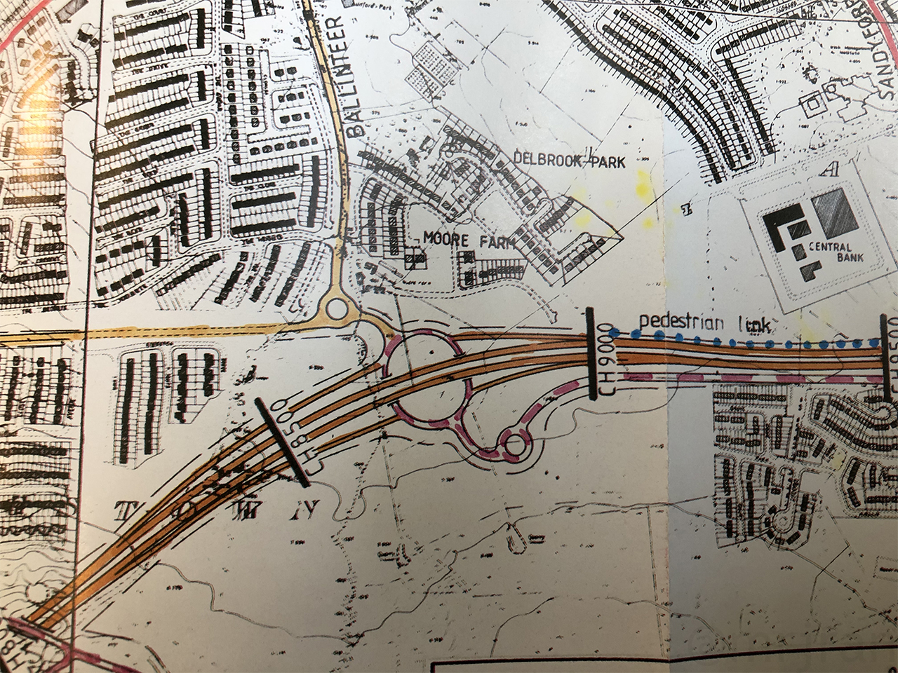
Existing roads were upgraded and new local roads were built. One new addition to the agenda was the Clontarf Embankment Road (now known as Alfie Byrne Road), which did the old Fairview Spur's job of relieving Fairview at a much smaller scale.
The Naas Road is an odd one. For a brief moment, things were stepped up a gear: a new motorway was planned to replace the old road to the north, and a junction was even reserved for it on the M50. That was never put into place, and instead piecemeal upgrades to the existing N7, as previously proposed, became the way forward.
As traffic levels began to rose, a second West Link Bridge was built, and the M1, M11 and M50 were all widened using their large medians which had deliberately been provided. All of the traffic lights were removed from the N7.
The Dublin Transportation Study was about 20 years early with its predicted road opening dates, and it didn't explicit predicted the economic boom of the late 1990s. But on the whole, the Dublin Transportation Study was put into place as expected.
The Sandyford Saga
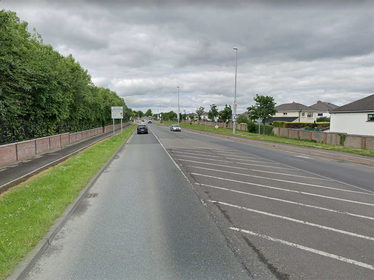
We now know how many of the motorways we have today got there. There are two more that went missing: first the Southern Cross Route never made it west to Saggart, and instead the M50 totally ignores it with a sharp bend near Firhouse.
Killininny Road is built broadly on the line that the Southern Cross Route was supposed to take. The grassy area around it suggests the line had been kept clear. But it seems the plan had been forgotten about as early as the 1980s. There was lots of talk about the M50, which progressed around here very slowly, and no mention at all of the missing western arm.
Then there was the saga at Sandyford.
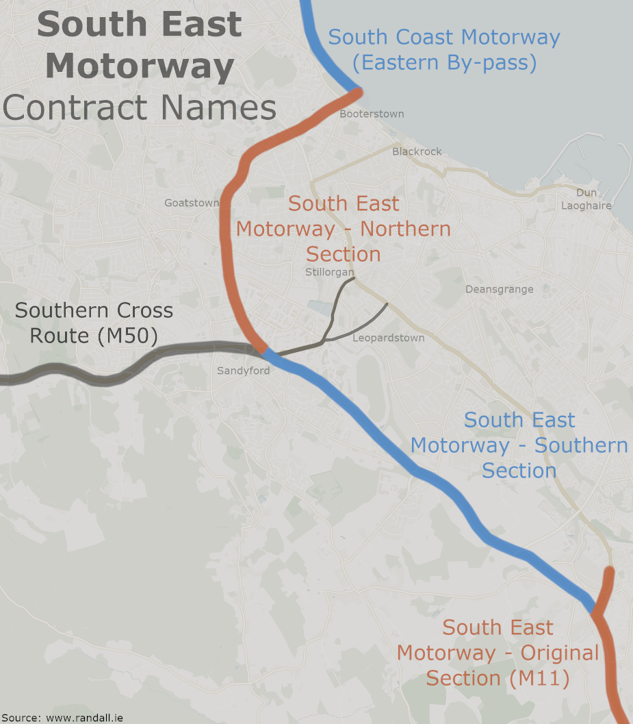
As the M50 was extended around the south side of Dublin, the plan was clear: it would temporarily end at a roundabout at Sandyford, and one day this would be replaced by the "South East Motorway", that being the Sunday name for the M11. You'd be able to head north on the M11 to Mount Merrion, or south on the M11 to Bray.
Further south, the M11 around Shankill and Bray had already opened in 1991, and was waiting for something to join it.
In 2005, "South East Motorway - Southern Section" opened. This joined up the little roundabout on the M50 with the temporary end of the M11 at Shankill, following the line that was first identified in 1971. The layout of the M11 at Shankill was even designed with the new road getting priority. Except something was different: they decided not to open this road as the M11, but as an extension of the M50.
By naming the project "Southern Section", it is pretty obvious that they were expecting a corresponding "Northern Section" to be built. Planning maps from the 1990s make it clear that "South East Motorway - Northern Section" would have taken the M11 from the old end of the M50 at Sandyford to Mount Merrion. But the finished layout of the M50 left no clues that this would be happening. At a very late stage in the process, it was decided not to leave room for it.
The different South East Motorway contracts: the Southern Section eventually opened as M50, while the top two remain unbuilt (705.47 KB, tap to enlarge)
The mystery deepens, because the road hadn't been cancelled. In 2000, the Irish government announced that not only was the 'Northern Section' still planned, but that the entire South Coast Motorway was back on the cards. The M11 would follow its intended route to Mount Merrion, over Booterstown, though this time it would tunnel under the seafront and link up to the new tunnel at Dublin Port. This was expected to open in 2009.
Inevitably, the project was postponed beyond 2009, and in 2016 it was effectively given the kiss of death by being excluded from the 2035 development plan, although the local authority are to keep the alignment clear just in case.
That alignment, going up the Drummartin Link Road, around Goatstown and north of Foster Avenue is the South East Motorway that has been planned in detail since 1971. The part around Booterstown, Sandymount and Dublin Port is not the original South Coast Motorway, but it's pretty close.
By 2035 the concept will be almost 70 years old. It's hard to see a city of the future accepting it, but it's impressive that the project has clung on this long.
Summary
There is something very sad about a book of bold civil engineering ideas which was destined to left on the shelf until it became irrelevant.
By the time the M50 made it to Sandyford in 2001, Dublin was a totally different beast to the place that had first created the idea of having a big ring going around the city. The suburbs had grown immensely and new shopping centres were littering it. Not to mention, the M50 never got the Liffey Crossing or Western Tangent that were supposed to help it out.
When you put it like that, it's no surprise that the M50 had already descended into chaos before it was even finished. As has been the common theme throughout this story, society moved on quicker than the city planning could.
It's probably worth remembering that by far the worst part of the M50 is between Tallaght and Blanchardstown, and that's also the section that has had the most alternative routes cut, including the extra river crossings, the fabled outer oribtal and the mysterious Saggart shortcut. The northern and southern parts of the M50 are slightly less painful, and they are also closer to what was already envisaged. That's not to say that the sketch briefly mentioned in chapter 1 would have worked perfectly, but it does suggest that half-measures don't work out well at all.
We don't have the original drawings for the interchanges along what's now the M50, but we do know that when it was eventually built it was designed according to a tight budget. It's likely that those tiny roundabouts that originally held the M50 together were an effort to keep costs down, as well as a reflection on Ireland's bleak economic outlook in the 1980s. The first part of the M50 didn't even have emergency phones, as had been used on main roads across Europe since the 1960s.
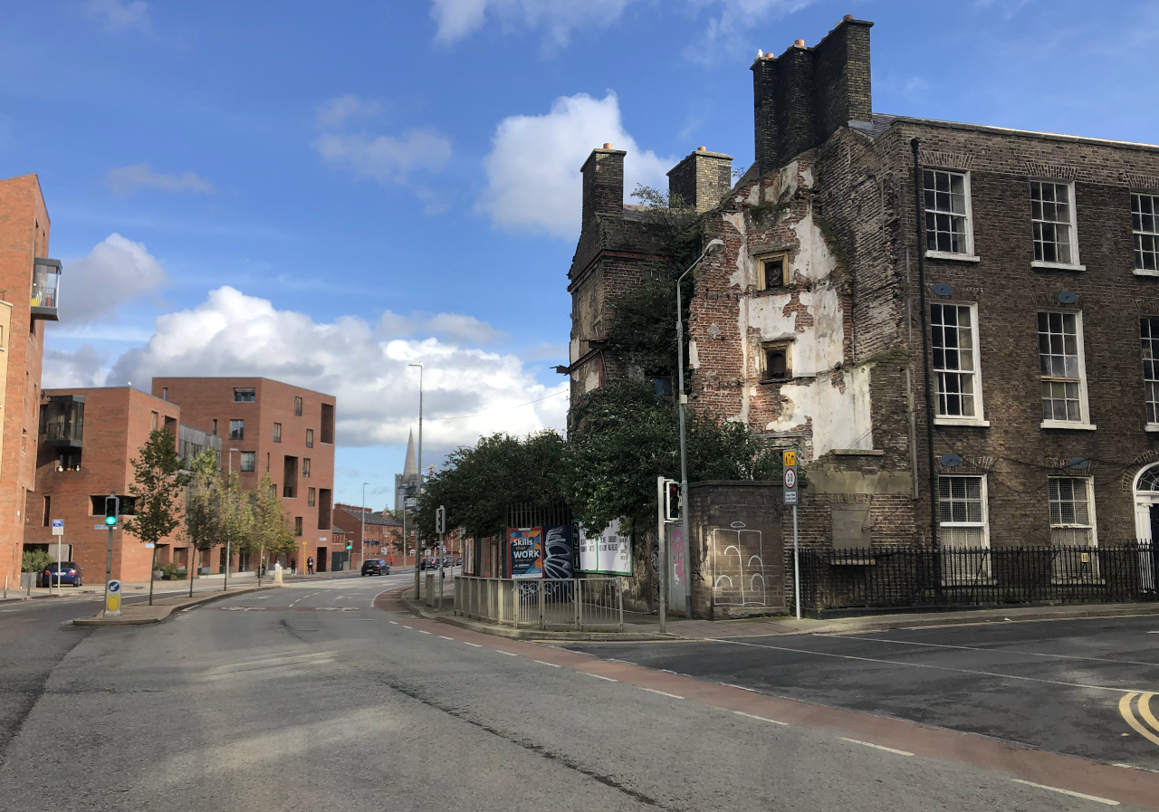
Compromise can be seen elsewhere too. St Patrick's Cathedral was spared the indignity of having a flyover at the end of its road, but instead it got the dual carriageway Patrick Street right outside its front door. This road was wide enough to be destructive, but too narrow to stop the traffic queueing.
St Colmcille's Way and Killininny Road are built on land wide enough to be the Southern Cross Route. (Picture: Google)
Other strange planning decisions can be explained by what wasn't built, too. In Blanchardstown, the Coolmine Industrial Estate was placed there because there would have been a junction with the M4 motorway immediately to the south. As the planned route of that motorway is now houses, the industrial estate looks a little odd being surrounded by parkland and residences. It's the same story in Clondalkin, and we know about the green "protected lines" where land had been kept clear elsewhere.
Was Dublin Corporation right to pin all its colours to the Inner Tangent? According to 1970s logic, they had the right idea. Their mistake was being too hesitant and allowing the case against them to gain momentum. Perhaps they underestimated the scale of the resistance to change.
From a modern perspective, it's a different answer. As a society we are now less obsessed with building for the future and more interested in preserving what we have; both physically and in terms of communities. We now have a totally different relationship with streets and cars. Not to mention, by now the Inner Tangent and urban motorways would have become a maintenance liability that would be expensive enough to bankrupt a medium-sized city.
Personally, as much as I do have a soft spot for a crafty use of flyovers and optimistic ambition, I think it's good that these things weren't allowed to fully let rip in Dublin. Badly-planned infrastructure divides cities, it changes the culture of how people behave and get around - it can change the feel of a whole place.
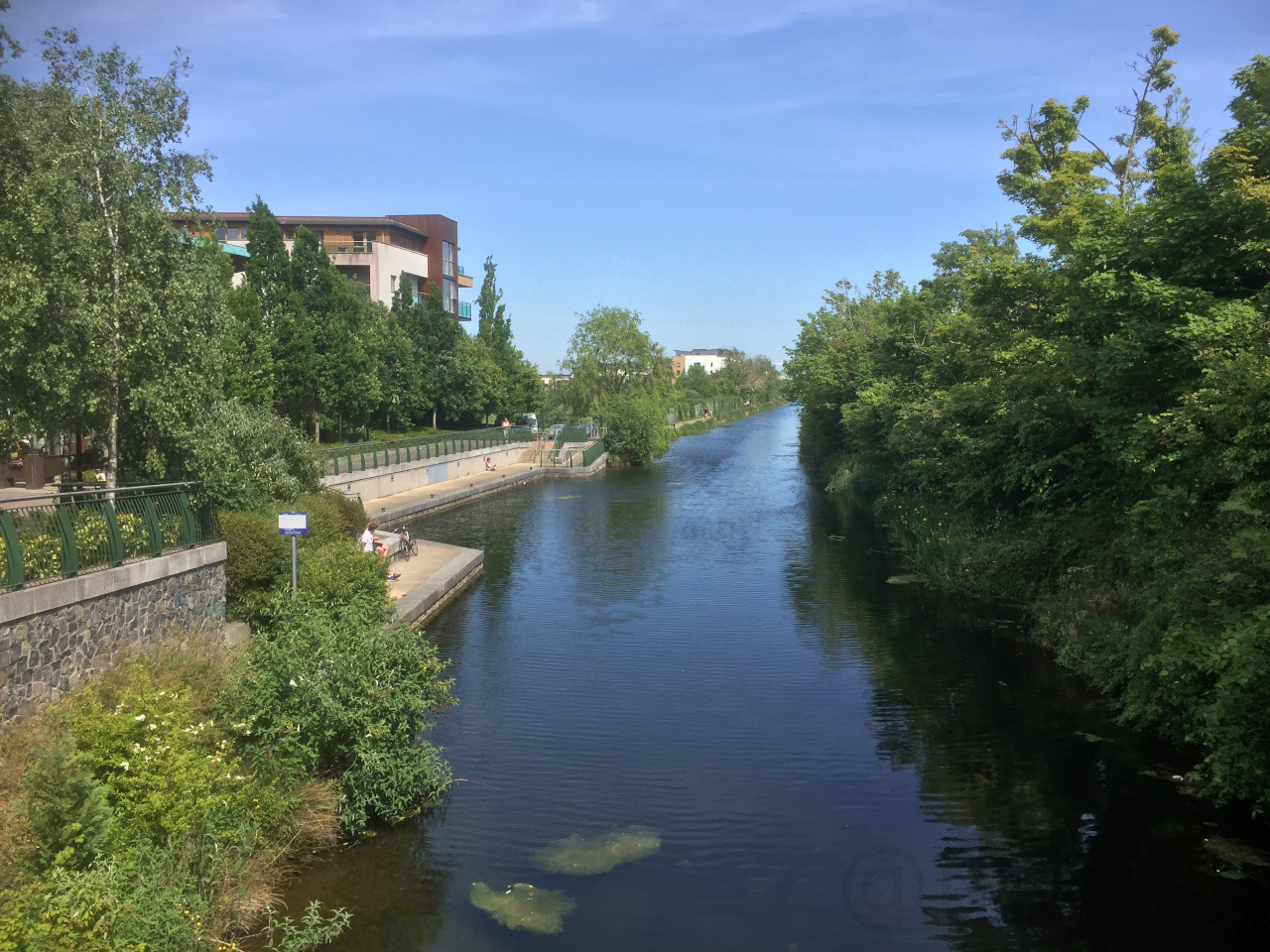
The two canals have since been restored, and since 2020 it has been possible to walk the lengths of both canals in Dublin. Clearly these are much more pleasant amenities without traffic thundering on top of them. While I realise in the real world some greenery will need to be sacrifices, the value of a pleasant amenity can't be understated.
A sunny day on the Royal Canal, where the Ashtown Interchange would have been.
What I think is a shame is that the failed plans were allowed to do so much damage. All over the city we have examples of depressing areas which hadn't been maintained properly. Many of those buildings were old and unfit for purpose, yes, but their decline could have been much better managed if the intention hadn't been to clear the whole area.
The Clanbrassil Street corridor is probably the biggest city centre road scheme we have to show for all this history, and while it's good that all the decrepit buildings have gone, what replaced them was nothing remarkable.
Four well-remembered pubs near St Patrick's Cathedral which were all removed for that road are often given as an example of a place losing its soul in the pursuit of efficiency. Compare that with the places that resisted demolition: Temple Bar (pre-tourism), Richmond Street (up to its recent gentrification) and parts of Parnell Street were all able to develop a vibrant charm which often grows under the threat of regeneration.
Elsewhere, we have many examples of random sections of fast and wide streets which were built on the footprint of something more determined. And we have that uninspiring architecture that replaced magestic old buildings which apparently had to go.
These are all the scars of urban ambition. They aren't pretty, but their story certainly makes places interesting.
The title of this feature was taken without shame from Jay Foreman's fantastic Unfinished London series, which would be of interest to anybody who is interested in urban planning or strange local authority decisions.
If you enjoyed this feature, you may want to read about the London Ringways.
Base map credits: Leaflet, © OpenStreetMap contributors © CARTO.