Central Dublin Traffic Plan (1973)
This is chapter 3.
Contents:
- Chapter 1: First Effort
- Chapter 2: Motorways
- Chapter 3: City Centre
- Chapter 4: Outcome
The Dublin Transportation Study from chapter 2 had created a network of new, major routes to get traffic in and out the city.
What it had totally ignored was the city centre, where the study simply assumed that the Dublin Corporation's Inner Tangent from chapter 1 would continue as had been proposed.
The Central Dublin Traffic Plan, prepared by R. Travers Morgan, was published in 1973 and commissioned by Dublin Corporation to establish what changes were needed in Dublin City Centre to allow the historic road network to integrate with the new motorways.
Travers Morgan had recently completed a similar study in Belfast, which ruled strongly in favour of the Belfast Urban Motorway. In Dublin, the Central Dublin Traffic Plan did at least have some understanding of the concept of preservation, but it limited this to specially designated historic areas: The Quays and the Georgian East. Other areas were, it seemed to think, not worth keeping.
Taking A Tangent
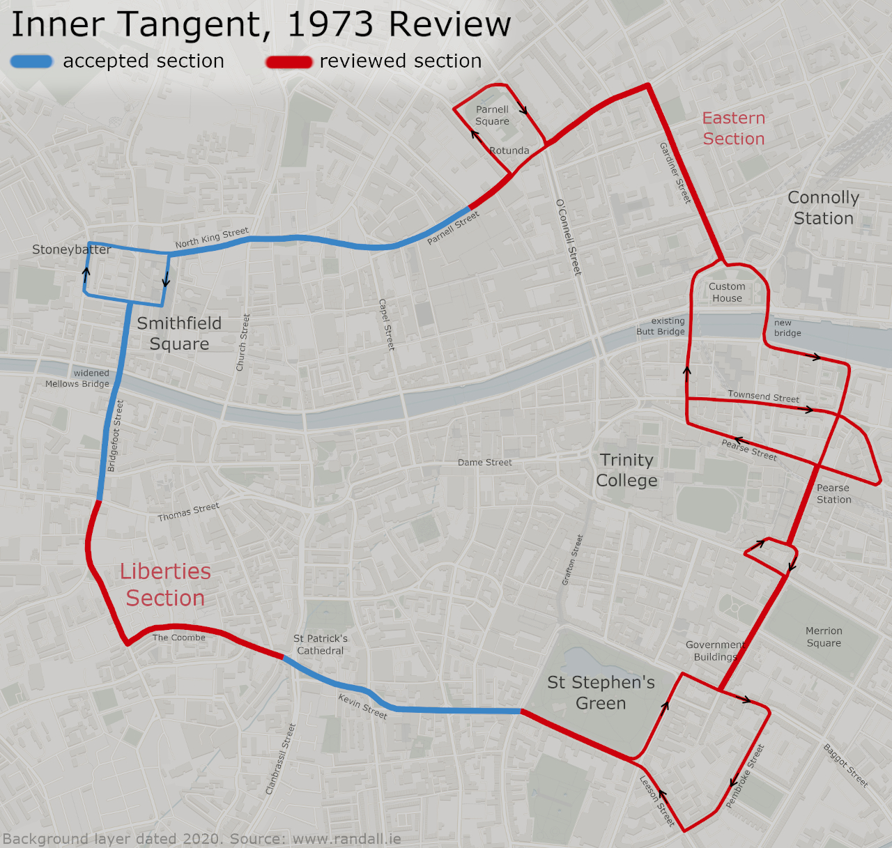
Mostly, this study's time was consumed with two parts of the faltering Inner Tangent project. The Corporation believed there were two contentious sections: the entire eastern half, from Parnell Square to St Stephen's Green, and the western section at The Liberties (Kevin Street to Bridgefoot Street).
When you look at that on a map, there wasn't an awful lot left:
The controversial sections of the previous Inner Tangent route that were now due for review, highlighted in red (1.41 MB, tap to enlarge)
The study agreed with the Corporation that it wasn't worth having the eastern section tip-toe its way around Georgian Dublin when you were going to have the Liffey Crossing motorway do the same job along the same corridor. There was no need for the eastern section, it said.
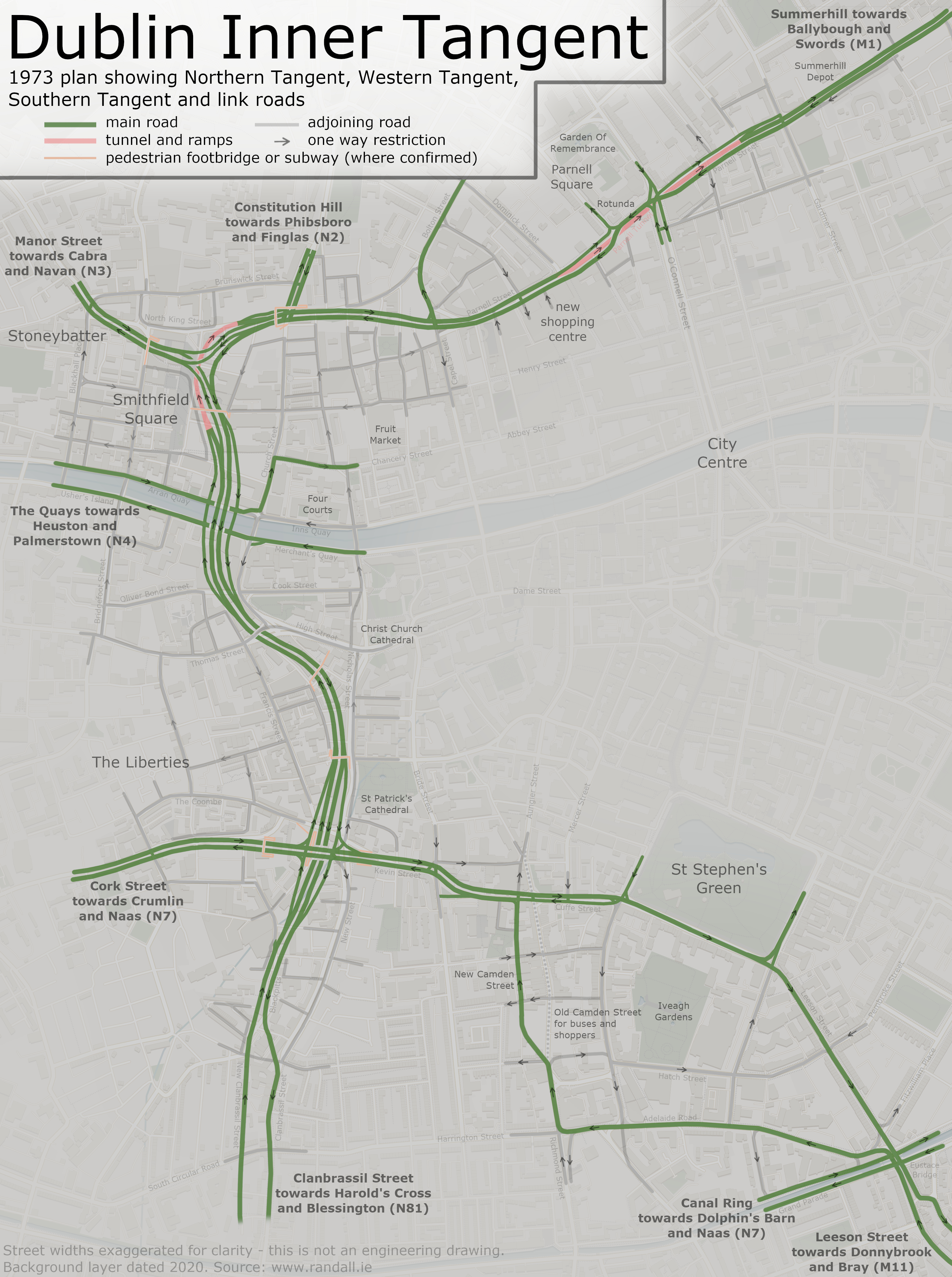
The remaining three sides of the Inner Tangent were broken up into sections, and analysed separately. A map of the full proposal is included further down.
Southern Tangent
A new one way system was created at St Stephen's Green. Starting from Leeson Street (N11) at the canal, it would use Adelaide Road, and then a new road that would be built down the west side of Camden Street, roughly along the line of the existing service roads and laneways. The return would be via St Stephen's Green and Leeson Street.
This would be part of a dense network of one way restrictions that would provide numerous routes for local traffic to reach different streets. Principally, it involved St Stephen's Green operating in an anti-clockwise direction.
Cuffe Street and Kevin Street would be widened to become dual carriageways (D2). One brief section near the cathedral would be eight lanes wide in total.
Instead of widening and extending The Coombe, which had proven extremely unpopular, a new road would be built to the south. This is now called St Luke's Avenue.
This system would allow the southern section to not just form part of a ring, but to help traffic get in and out quickly using Leeson Street or Cork Street. The new roads - in fact all of the new tangent - would have most of its side-turnings closed, to keep traffic speeds high.
The colourful laneway that is Liberty Lane, which would have been cleared to create New Camden Street.
Western Tangent
The western section was the one with all the problems, as it had been primarily routed through The Liberties which was in need of investment but, understandably, people who lived there didn't want it turned into a ring road.
The new proposal formed by far the most memorable outcome of the whole study.
The Western Tangent technically extended all the way down to Harolds Cross. Starting here, a new road for inbound traffic would have been created, using the existing laneways and the street called Blackpitts.
The widening of Clanbrassil Street previously mentioned had not been carried out, having already been amended several times, so it could be amended again to take in the new proposals. This time, much of it would be saved - especially the New Street end - but other properties would be lined up for demolition instead.
At Kevin Street, a large diamond interchange would be built, with the Western Tangent diving underneath in an underpass. Diamond interchanges are generally known for being small, and they are, but in the context of a city centre it would still have been massive. Several pedestrian subways would have been provided. St Patrick's Cathedral would have overlooked the new flyover.
From here, the road would run fast with three lanes (D3) and a 60kph design speed. It would head west, roughly following John Dillon Street and Lamb Alley, but dwarfing the laneway that's there now.
The redbricks that were in the path of the Western Tangent; these are on John Dillon Street.
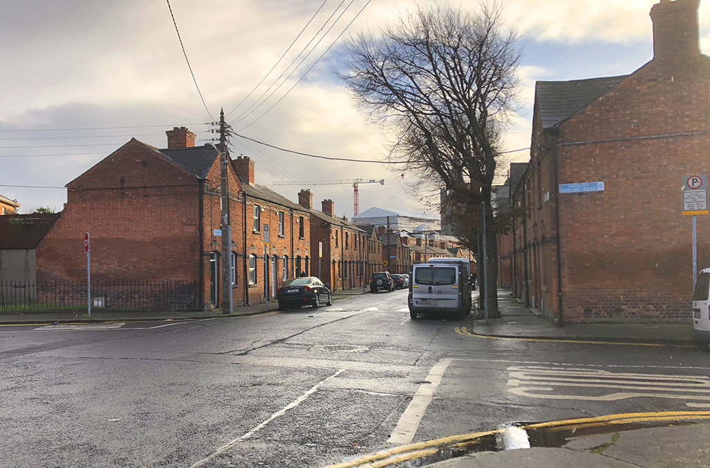
The road would pass underneath Cornmarket (High Street), and then cross the River Liffey at Ushers Quay. Here, another diamond interchange would straddle the river, requiring three new bridges: two at river level and one to fly over them all.
The decision to put a flyover here was rather poetic (or rather insensitive), because this is understood to be the exact spot of Dublin's hurdled ford, from which Dublin gets its Irish name. Immediately to the east is Father Mathew Bridge, which was the site of Dublin's first bridge.
An alternative option for this interchange had been considered further west, closer to Bridgefoot Street, but the chosen route was considered to be less destructive overall.
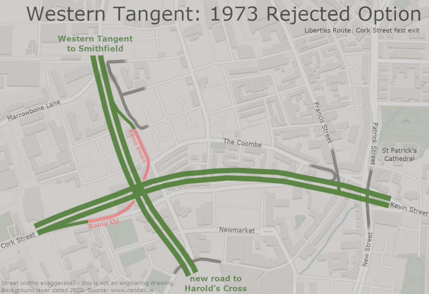
The Western Tangent would continue north, narrowly missing Smithfield Church, then crossing into Smithfield where it would experience a compact Y-shaped interchange, immediately east of Smithfield Square. Prussia Street would emerge from the middle, forming a route out of the city via the N3.
Travelling northbound, the Western Tangent would take a long underpass, diving under the whole complex. Long footbridges would carry residents acros the road. The Western Tangent would then come to a halt at a set of traffic lights at a widened Constitution Hill, which would form a route out of the city via the N2 towards Glasnevin and Ballymun.
The Western Tangent was a high capacity road, because the study felt that this was necessary. It believed that a road like this would keep all the through traffic out of the city centre.
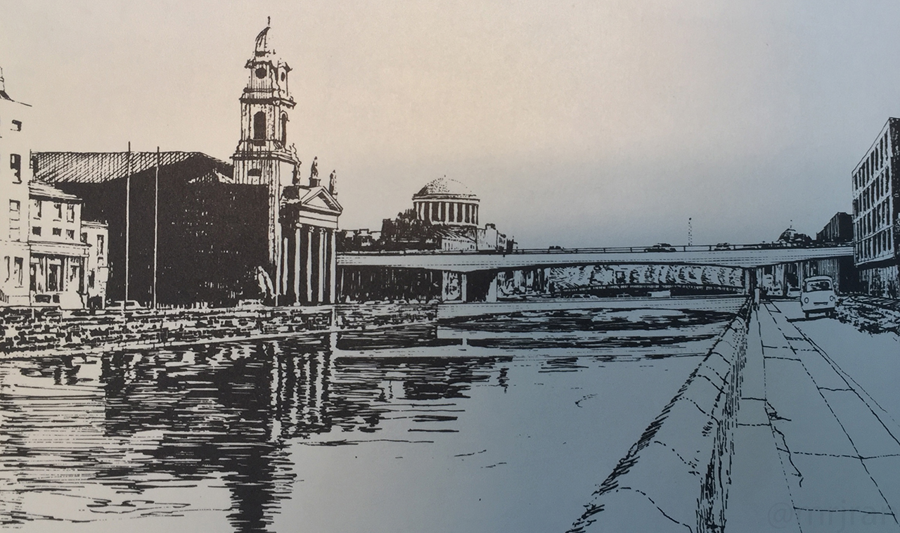
Above: A sketch of the Western Tangent interchange planned for Ushers Quay.
Below: The same scene in 2020.
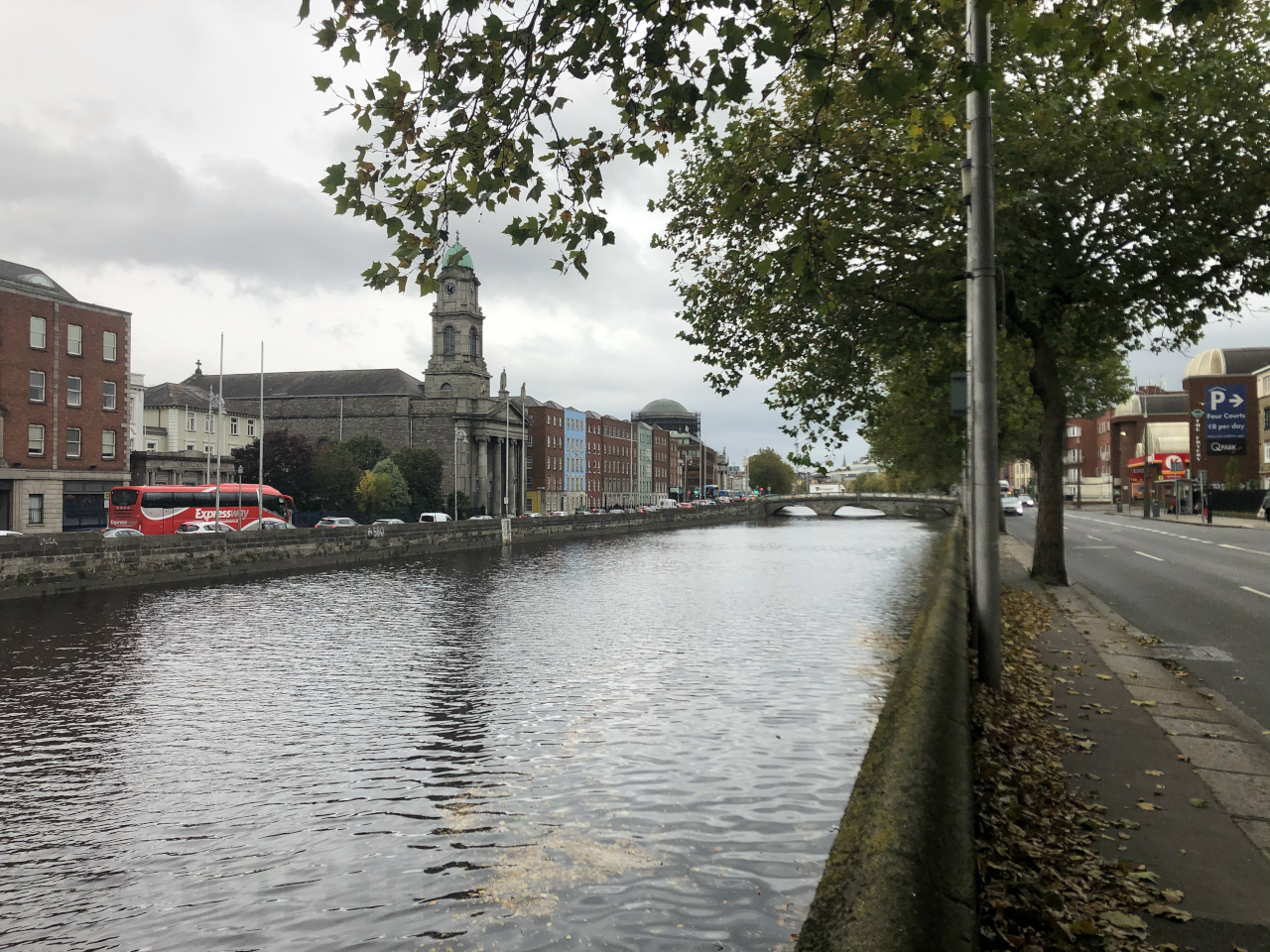
While engineers believed they had chosen the best route available, and at the time much of this land was in a poor state, they still knew it was destructive. They suggested the Western Tangent be promoted to residents as a regeneration scheme, and highlighted all the plots of land that could be developed afterwards.
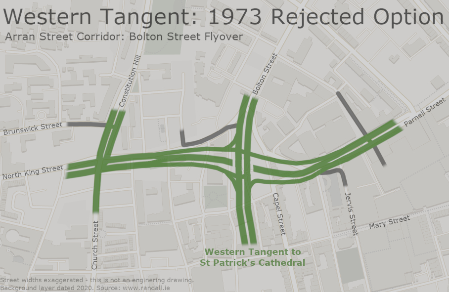
As it was a totally new route, several alternative routes were drawn up and abandoned. One of these went through The Liberties, with a short tunnel onto Cork Street, providing a fast route out of town. Another involved a two-way underpass on North King Street and a tunnel under Lord Edward Street.
Discounted options: Cork Street Underpass (for the rejected Liberties route) and Bolton Street Flyover (for the rejected Arran Street route). Tap either to enlarge.
Northern Tangent
In comparison with the Western Tangent, the Northern Tangent was much more chilled. But it had a few tricks of its own.
Starting from North King Street, the road would head in a straight line to Parnell Street, where traffic would be able to turn into Capel Street or Bolton Street - from Bolton Street you could then join the Royal Canal Motorway and head west.
After this a few more side turnings would be available, including an inbound route via King's Inns Street. Some of these turnings appeared to be speculative on the basis that a large shopping centre (larger than the ILAC Centre that is here now) was going to be built, so they envisaged people driving straight from the Northern Tangent into the shopping centre car park.
This is arguably the closest any part of the Inner Tangent gets to the city centre. Today Parnell Street is a busy shopping street, with several well-regarded districts branching off it. Strictly speaking you can drive from Parnell Street into the ILAC Centre car park, it just has a lot more pedestrians than the Northern Tangent expected.
At Parnell Square, there was a challenge. The protected Rotunda Hospital and adjacent Ambassador Theatre came too close to the road, making it too narrow.
To get round this, a two-lane tunnel would have been built. Outbound traffic would have the choice of either heading up the ramp and around the square, or entering a tunnel that would go under the hospital and come out the other side.
Inbound traffic would use the surface roads, passing through the traffic lights at O'Connell Street. To make space, the Parnell Monument would have been moved further down O'Connell Street.
Standing where the Parnell Tunnel would have emerged. Everything on the right would have been demolished; the buildings on the left would have stayed.
The tunnel itself wouldn't be a huge engineering feat, but once you factor in the ramps needed to get underground, you'd have about 500 metres of cutting - quite a lot for a shopping street!
After Parnell Square, the study rejected the option of using Cathal Brugha Street, arguing that losing the charm of the Parnell Street eastern district would be less disruptive overall. After the junction with Gardiner Street, the Northern Tangent would continue along Summerhill, gaining a local access road. Parts of Summerhill were about to be largely demolished as part of a large social housing scheme, so the new road would be integrated with this.
The dual carriageway (D2) would have been extended to Ballybough Road, where traffic could join the Airport Motorway to head north. This was expected to be the main destination for traffic on the Northern Tangent.
One of the interesting thing is how many streets would have been divided in two by the new road. For example Church Street, now a major route out of the city, would have been turned into a dead end as a result of the Northern Tangent (North King Street) crossing its path.
A preview of the Western Tangent, as it makes its way between Smithfield and Christchurch, with north on the left
Tap to view a map of the full Inner Tangent route (6.34 MB)
Getting Started
The remaining three sides of the Inner Tangent would have been dual carriageway throughout, leading to widescale demolition but also providing the opportunity to re-shape the city.
The study also included a list of "quick wins". These were parts of the Inner Tangent which would run through land that was already vacant and in a poor state, and therefore were ready to be built on with little negotiation required. These were:
- Cuffe Street (entirety)
- Kevin Street (western end)
- St Luke's Avenue (western half only)
- North King Street (eastern end)
- Parnell Street (western end)
- Summerhill (western end)
If you look at these on the map, you will see that these almost all exist as inner city dual carriageways. You'll also notice that many of these streets were a top priority for construction in chapter 1.
Part of Summerhill was built as planned, showing us what most of the Northern Tangent would have looked like.
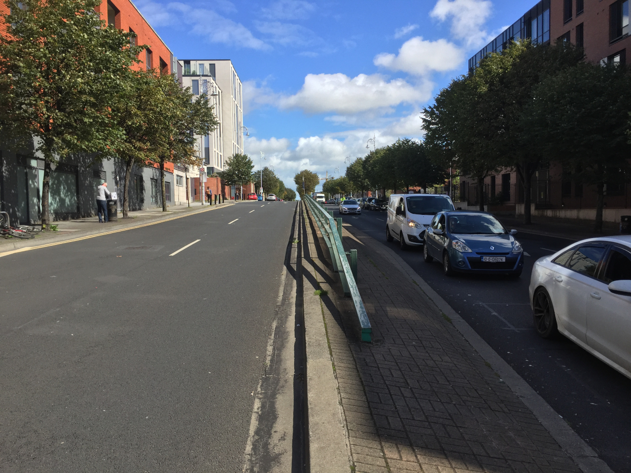
In addition, there was a list of "easy wins", which were parts of the Inner Tangent where the land wasn't already available but the benefits of building them were great:
- Kevin Street (eastern end - linking the first two above)
- St Luke's Avenue (eastern half - linking it to Kevin Street above)
- The new road between North King Street and Parnell Street
Two of those weren't built. As a result, today we have the strange situation where the Parnell Street dual carriageway totally gives up before it gets to North King Street, and likewise Cuffe Street doesn't last very long.
We will explore why things went so wrong so quickly in chapter 4. But first, let's look at the rest of the Central Dublin Traffic Plan.
The full Central Dublin Traffic Plan, showing the many one way restrictions that would be applied (6.22 MB, tap to enlarge)
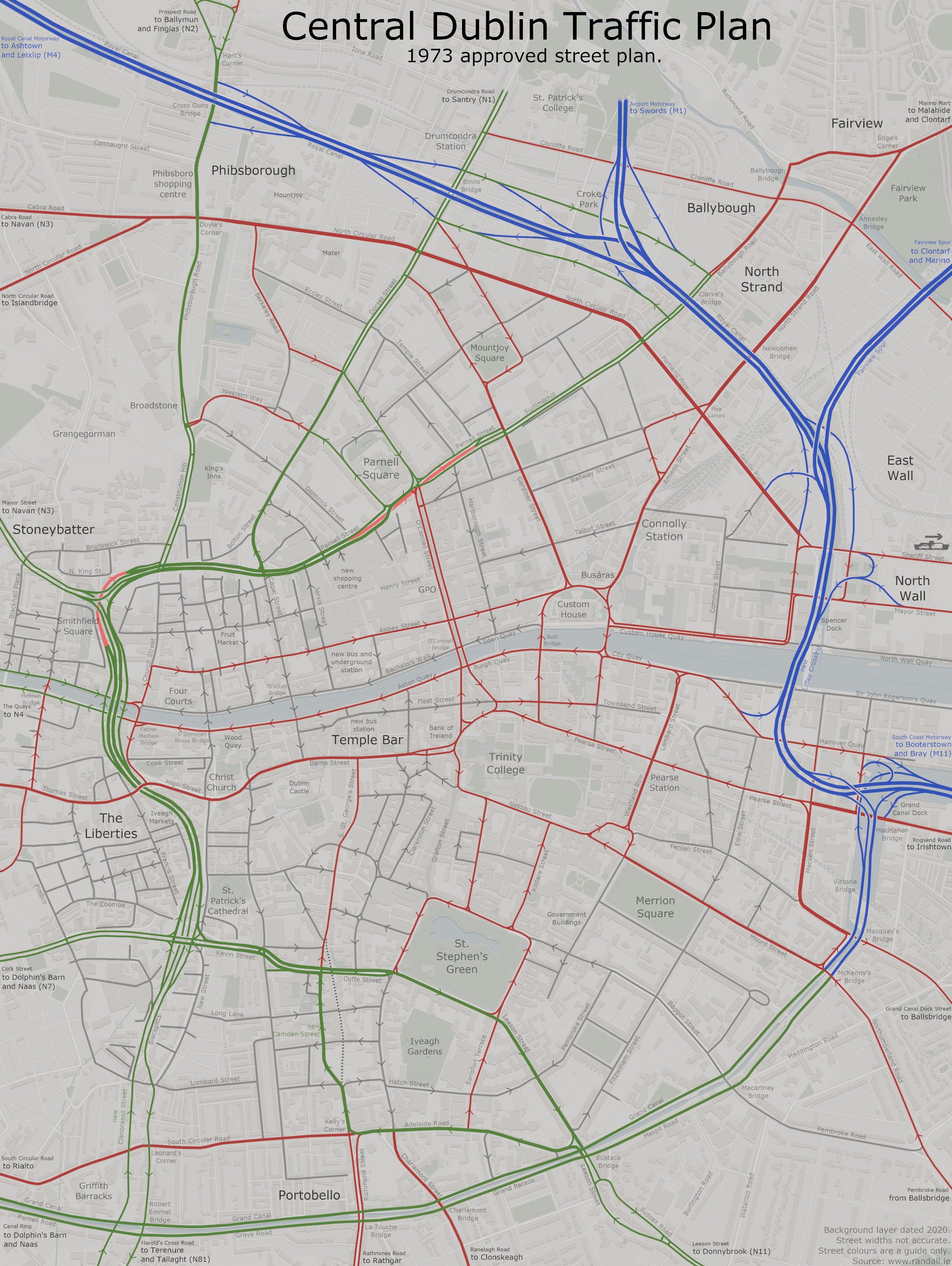
More Than Just Roads
The Inner Tangent - specifically the Western Tangent - was the main aspect of the Central Dublin Traffic Plan, and was what it would be known for. It really believed that a good flow of roads in and out the city would keep the central section flowing well.
There was more to it than just that, though. In fact, despite being published in 1973 and being obsessed with keeping traffic moving, some of the recommendations of the study were rather contemporary.
Even where it insisted that major roads be built, it did at least acknowledge that they wouldn't be popular, and suggested the new roads be well-landscaped to keep communities on side.
Elsewhere, it supported the pedestrianisation of Grafton Street, Henry Street, Earl Street and Mary Street - all being trialled at the time - and wanted Custom House Quay and half of O'Connell Street to be added to the list. Specifically, O'Connell Street would have been made much narrower outside the GPO, to allow a pedestrian plaza to be created there.
St Michael's Close would be widened and used instead of Winetavern Street, giving the immediate surroundings of Christ Church Cathedral more space.
It wanted to invest heavily in bus services, with a network of dedicated bus-only roads running around Tallaght, Lucan and along the old railway lines. Bus stations would be built at Temple Bar and Ormond Quay (now Millennium Walkway). The old Camden Street would be used by buses only, though the idea was that with little traffic it would be safe for shoppers to walk around. Nassau Street and Aungier Street would be buses only, too. It wanted to see a dedicated Airport Express bus run along the new motorway.
Consideration was given to an underground rail link, connecting the existing lines at Lansdowne Road and Phibsborough. Public transport was described as a "vital" part of the system.
The recommendation for a Dublin Underground, highlighted in blue, alongside the existing railways (978.99 KB, tap to enlarge)
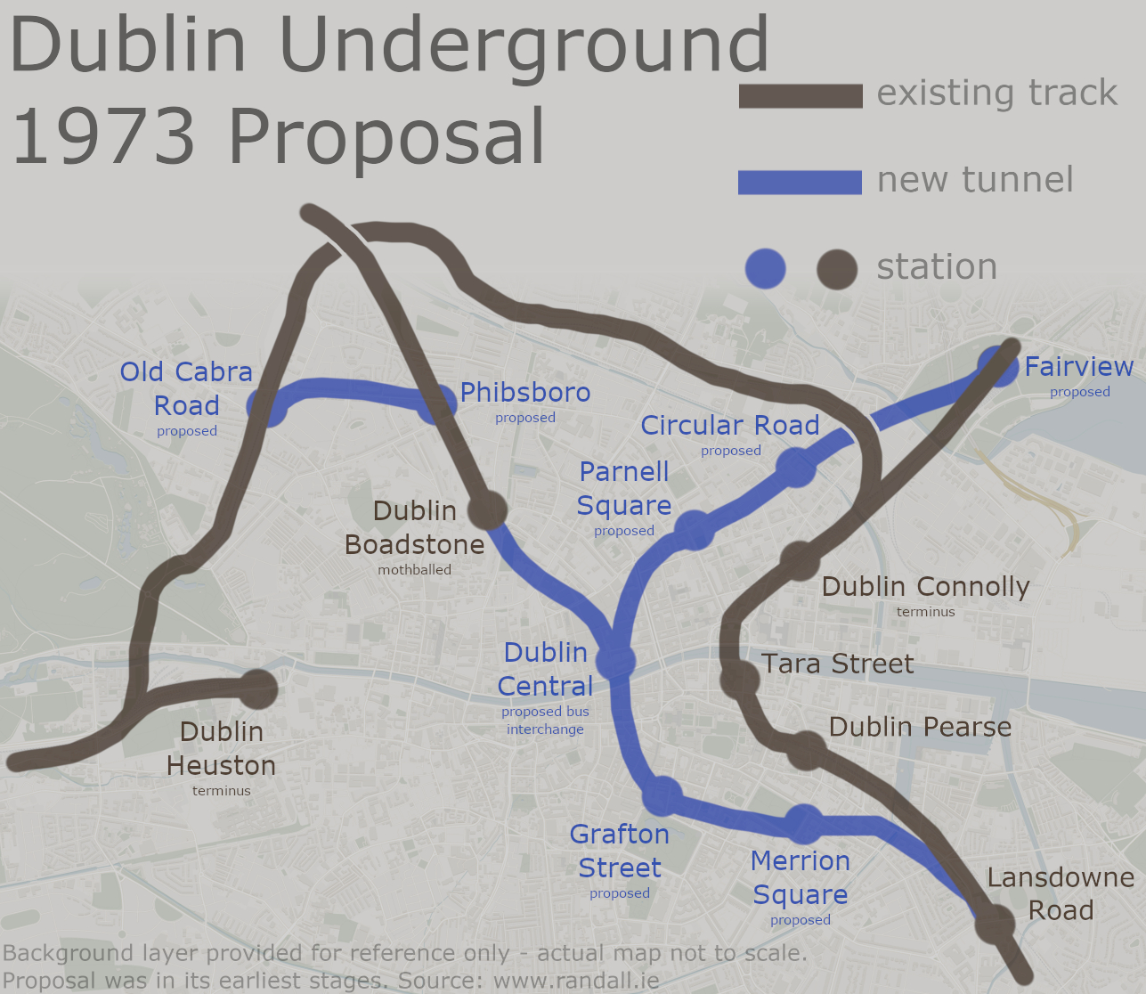
The study strongly encouraged that on-street parking be removed and strictly enforced where available, though this was mainly so that all of the available roadspace could be dedicated to moving traffic. New car parks would be built in outer areas to reduce the amount of traffic heading within the Inner Tangent.
An extensive one way system would have been created, with seemingly every single major road in the city centre running in one direction only. It would even tamper with inscrutable forces by changing the arrangement on the Quays, meaning both sides of the Liffey would be for outbound traffic only. Inbound traffic would have to follow a new route along Abbey Street.
A lot of this would involve taking advantage of existing wide corners at certain junctions which dated back centuries. This includes Arran Quay and Harcourt Road, where one way systems would be able to negotiate corners by using all the space to make it a smooth turn.
A historic widening of the street at Arran Quay (courtesy of the Wide Streets Commission), which would have been used to create a major left turn - similar to what was here until the 2020 cycle lane works.
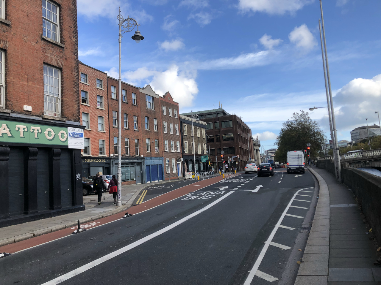
It is difficult to get a practical sense of what this would have been like when it is only optimistic lines on a map. While there would be traffic lights everywhere, the dominance of so many free-flowing roads would not make life easy to anybody walking or cycling around.
Travers Morgan were only commissioned to study Dublin City Centre. What happened beyond there wasn't really their concern.
Looking at it now, the Central Dublin Traffic Plan seems to push an awful lot of traffic towards Terenure and Donnybrook, and to a lesser extent Phibsborough. Donnybrook technically had the South Coast Motorway to relieve it, but that would be a long way round if you were coming from the Western Tangent.
With that in mind, you wonder whether there was an unwritten assumption that more new roads would eventually be needed to keep everything moving as it leaves the city. One map does appear to show a widened road taking a destructive path through Donnybrook, but it's not clear whether that was accurate or just a lazy drawing of the road that is there today.
As far as the city centre itself is concerned, one assumes that the Central Dublin Traffic Plan would have successfully raised traffic capacity and speeds across the city. The catch being that, if that capacity was reached, there would be nothing that could be done about it. You can only 'wipe the slate clean' so many times.
In addition, these streets would have been lined with replacement buildings designed in the 1980s, totally changing the look of the city. Many of them would be deliberately designed to have their fronts facing away from the road, creating a better experience for residents but a depressing view for drivers.
None of those reasons were why it wasn't built, though...