Dublin Transportation Study (1971)
This is chapter 2.
Contents:
- Chapter 1: First Effort
- Chapter 2: Motorways
- Chapter 3: City Centre
- Chapter 4: Outcome
The 1967 Dublin Region Plan had established a number of corridors where new motorways could radiate out of the city centre in different directions.
The Dublin Transportation Study's task was to take that starting point and turn it into a workable proposal for the county's traffic plan.
As the Irish state had no experience with motorways, the United Nations arranged for the US Department of Transportation to offer their expertise and computer programming. The result was published in 1971 by Ireland's An Foras Forbartha, and a full map is included further down.
The key difference between 1971 and 1965 was that this study was keen to route the motorways around any valuable buildings. They would instead follow railways, poor-quality or derelict buildings and parkland.
British readers will be surprised to hear that this motorway network was a network of commuter roads. In Britain, fast roads had been planned since the 1920s to speed up journey times between cities. In Ireland, roads were still the responsibility of the county council until 1993(?), so there wasn't much joined-up thinking.
The one exception to that was the 'outer orbital' mentioned at the end of chapter 1. As this would have existed almost entirely outside the county boundary, the Dublin records contain no further mentions of it. It's likely that Kildare and Meath never spoke to each other about planning it. However, when you look at the roads we are about to unveil here, you do wonder if the Dublin Transportation Study assumed the outer orbital was still on the agenda.
Meanwhile, work was now underway on the legal process required to create motorways, and this would be ready just a few years after the recommendations of the Dublin Transportation Study had been published.
The study envisaged a network of roads that it wanted to see all open by 1991. These were all commuter routes, to help locals get around the suburbs. Each interchange was described as either "diamond" or "full access". It's not clear if those were accurate descriptions or just euphemisms for "simple" and "complex". The titles imply that full road layouts are available, but most of them haven't been uncovered yet.
(Technical note: This study did not allocate road numbers. T numbers were still in use at the time, with N numbers coming in soon. For convenience, we will refer to existing roads by the numbers they held in 2012. The study did state that the existing road network would be reclassified to suit the changes, so while you are welcome to have your own guess at what each road would actually have been numbered - and we'll be doing a bit of educated guesswork - it's all alternative history territory.)
Tallaght as you'll never see it again: large green spaces and a dense grid of fast roads with large interchanges. But this was just Myles Wright's vision - we're interested in the concrete plans.
Royal Canal Motorway
The Royal Canal Motorway would have started at the Liffey Crossing, a new, major river crossing that replaced the previous Liffey Bridge idea by being both wider and much higher up. 58,000 vehicles a day were expected to use it from opening.
This gives us a start point for the motorway in Spencer Dock. It would, as the name suggests, have followed the Royal Canal, which would have been filled in. The Canal was in a poor state at the time, and it offered a clear route that the state already owned.
There would have been a knot of ramps (slip roads) in North Wall, joining the R101 to Dublin Port. In the middle of this (at the site of Docklands station) would have been a fork for the Fairview Spur.
Soon after there would have been a fork for the Airport Motorway, positioned above the old Croke Park (a full access option was considered but declared unnecessary). At Ballybough Road, two ramps would have would have run parallel.
There would have been an all-access diamond junction with the N1 Drumcondra Road, where the Ballybough Road ramps would have joined. Soon after, there would have east-facing ramps connecting to the N2 at Phibsborough. The study considered the danger of weaving between the N1 and N2, but reckoned the length was just long enough.
The layout of the Royal Canal Motorway within Dublin City Centre, laid on top of a modern (2020) map (2.64 MB, tap to enlarge)
After Phibsborough the environment becomes much less densely-packed, and the drive would have been less stressful too. Consideration was given to converting the old Broadstone railway line to a fast road into town, but this was ruled out.
The next junction would have been at Ashtown, east of the canal bridge. Ashtown itself wasn't the huge suburb that it is now; this junction was here to serve the Northern Spur, a new link road that would have ran from the N3 to the south, to the N2 to the north, creating a new corridor for development.
Next the road would cross over the N3, and have an interchange with the M50 at Castleknock. The wooded embankment near the toll sign gives away the precise location where the flyover would have been.
Soon after there would be another junction, this time serving Blanchardstown and Lucan. It would have been the main exit for both Blanchardstown Shopping Centre and Coolmine Industrial Estate, and a lot of traffic would have left here.
After this the plans get a little more sketchy. We know the road would have passed north of Lucan, and "near Leixlip", taking us to the county boundary where, as far as the study cared, the road would have ended.
The planned site of the interchange at Spencer Dock.
In 1994, a section of M4 motorway opened in Kildare, which conveniently ends at Leixlip, right by the county boundary. It is not a great stretch to suggest that this was intended to meet Co. Dublin's Royal Canal Motorway. The contract for the Lucan half of the Royal Canal Motorway would have been titled "N4 Corridor Motorway", again suggesting the finished road would have been called "M4".
The N4 Lucan Bypass, which opened without the flyovers in 1988, was included in the Transportation Study too, as an urgent priority. Lucan needed two major roads: what's now the N4 would have been the local road, and this Royal Canal Motorway would have been the main road.
All of the Dublin city centre motorways were listed as high priorities, but the Royal Canal section was near the bottom of that list. Its main purpose was to provide easy access to the west, especially for Dublin Port, that would prevent the need for HGVs to head through the city centre. The Dublin Region Plan had even suggested it feed straight into Dublin Port.
West of the M50, traffic levels were expected to be very low. The Royal Canal Motorway was the poor relation of the network, and to make its prospects worse, anger about its route inspired the creation of the Royal Canal Amenity Group.
Airport Motorway
The Airport Motorway is an easy one to make sense of, because it exists. The Airport Motorway opened in 1985; it would eventually be part of the road that starts at Santry and heads towards Belfast.
In this study, the Airport Motorway would have ran from the Liffey Crossing to Blake's Cross, near Lusk. In the early stages of the Dublin County Development Plan it was proposed as a more easterly route labelled "T1 Motorway"; by the publication of that plan this was the only road to be given a formal title, "M1 Santry to Swords".
Under the Dublin Transportation Study, the Airport Motorway diverged from the Royal Canal Motorway at Croke Park. It would then have crossed the sports ground and have an interchange at Whitehall. The exact location varies but it would have been somewhere near the crossroads.
It would then cross the park, with the next exit being at Coolock Lane. This was built in 1983, and from 1985 it formed the start of the M1 motorway.
However, it does fit with the phasing plan. This showed that the road from Dublin Airport to Coolock Lane would have been built first (it was), with it slowly progressing in each direction from there.
Curiously, the exit for Swords was originally intended to be at a junction with the road to Malahide.
The Airport Motorway would have been built to two-lane standard (D2M), but with space for a third lane. The link to the airport, which was a key part of the original project, was to be narrower, with no third lane needed.
One of the first drafts of the arrangement at Dublin Airport, showing a non-stop road layout and a suggested arrangement around the airport. At first I thought the trumpet interchange was a demonstration only, but closer inspection reveals space may have been left for it when the M1 was built (410 KB, tap to enlarge)
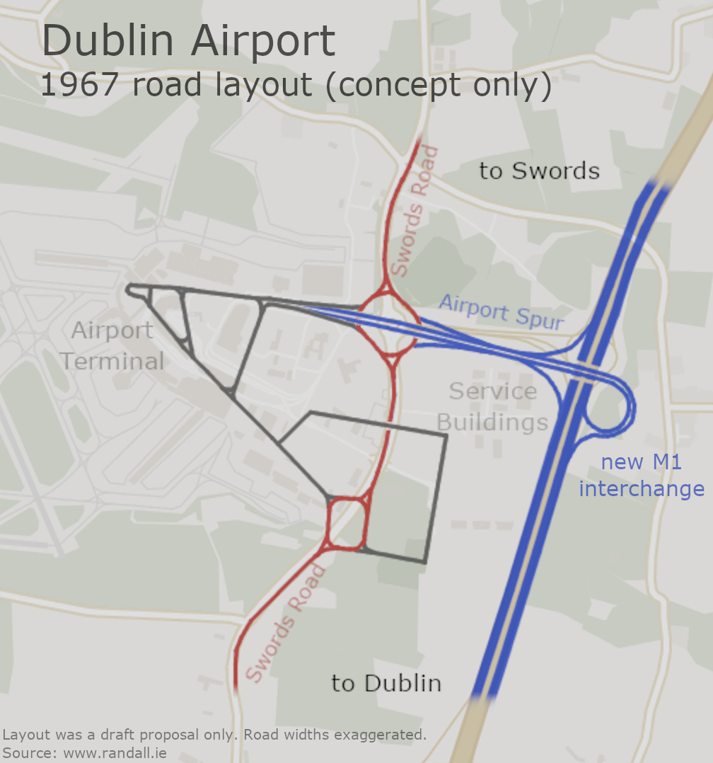
Another point that may be of interest is that the M1 was always expected to end at Blake's Cross. The idea was that the new road to Belfast, if one was ever needed, would run via Ashbourne and Drogheda, making the existing N1 into Co. Meath redundant. This route was preferred precisely because it didn't integrate well with the Dublin network, meaning that traffic would be forced to split up before it reached the city centre.
South Coast Motorway
People who know Dublin will be familiar with the saga of the South Coast Motorway, even if they don't know the name.
For the purpose of this study, the South Coast Motorway would have taken over from the Royal Canal Motorway at the Liffey Crossing.
There would have been a complex interchange on top of Grand Canal Dock, with exits for the Canal Ring Road and the local area. Pearse Street would have run underneath the whole complex; the skyscrapers that are there today are nothing compared to the concrete pillars that would have run overhead here. This is an area which had become almost completely derelict by the 1960s.
The road turns sharply eastwards, following the existing road to the large junction at Irishtown. Here there would have been another interchange. As this is mostly reclaimed land, this part wouldn't have been too destructive.
In fact, Dublin Port were planning to claim more land around what's now Seán Moore Park, so the Irishtown Interchange was effectively a blank canvas for planners. This would have been an exit for the industrial estates, but not for the East-Link toll bridge - that bridge wouldn't have needed to be built.
The layout of the interchange above Grand Canal Dock, laid on top of a modern (2020) map (2.29 MB, tap to enlarge)
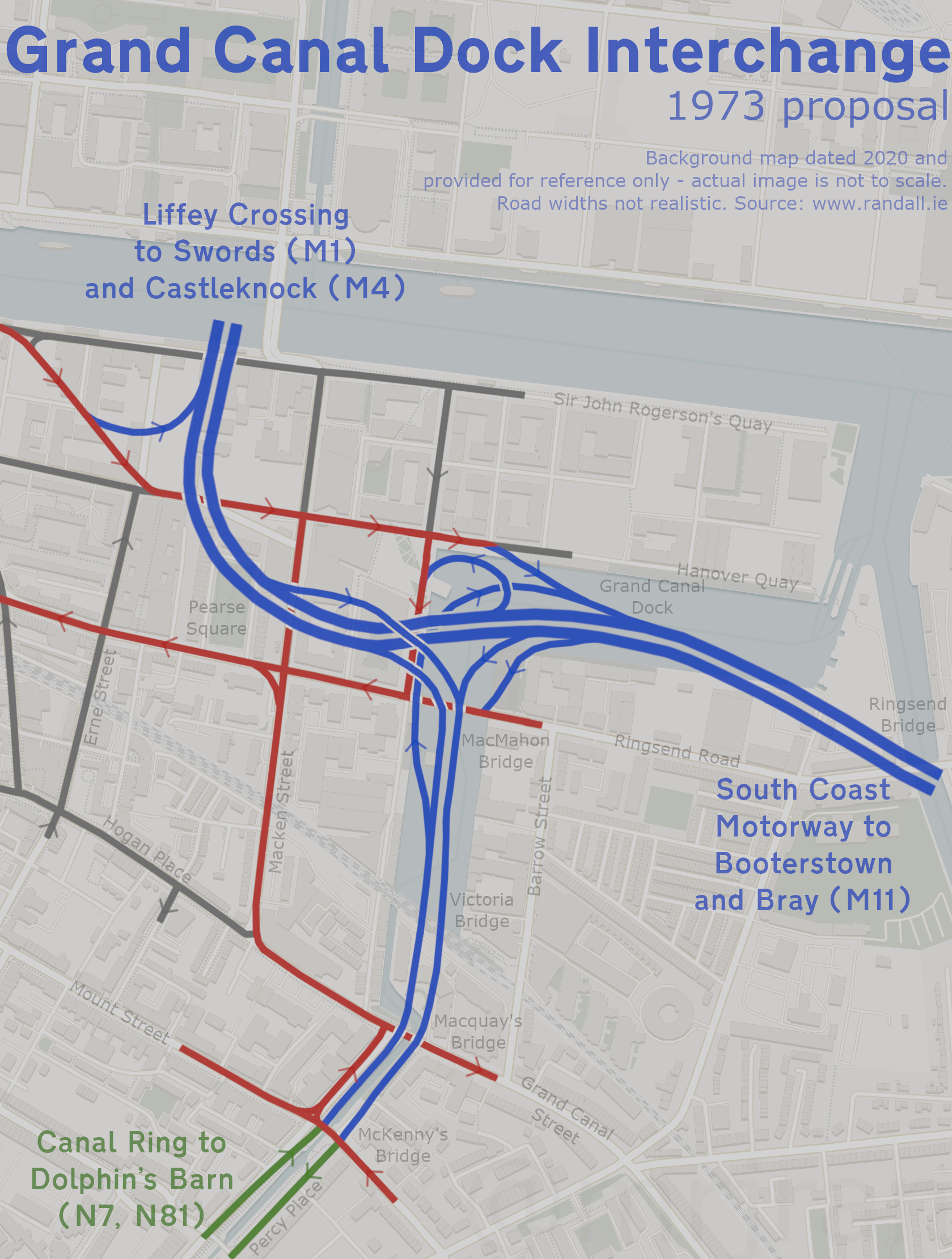
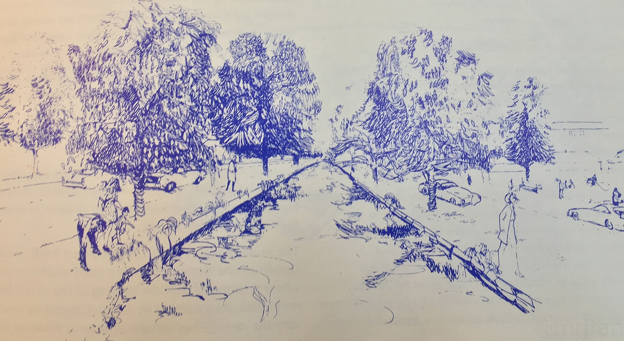
From here, the road would have run along the seafront at Sandymount. An embankment along each side would have been provided to try to hide the road, and each of those embankments would have been turned into a park. Frequent footbridges would have linked the two sides, with the coastal side having bathing areas along the waterfront. The road would have been built to two-lane (D2M) standard, with space to widen it in future.
The Sandymount Coast Road proposal wouldn't sound too bad if we had a totally blank canvas, but when you're tearing up an existing seafront to build it, it becomes much more difficult to get residents on board. The railway line at Booterstown (opened in 1835) provided some precedent that it could be done, with part of the old coastline having become a pleasant nature reserve. Unfortunately, that nature reserve was also on the line of the new motorway.
An artist's impression of the motorway and linear park at Sandymount. The sea is on the left, with the old shoreline on the right.
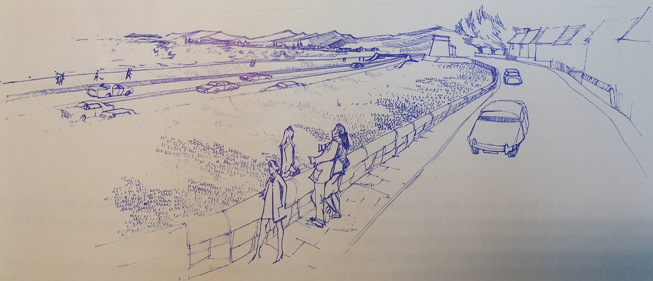
The Transportation Study was adamant this was the least destructive route to take, as utilising the coast line spared Sandymount village and Ballsbridge. Consideration was given to a spur, which would have continued along the seafront, through Dun Laoghaire, to Dalkey. That was removed from the plan, but it was recommended that the route be protected just in case it was needed later.
From Booterstown, the South Coast Motorway would have dipped under the railway, where there would have been an interchange with Rock Road. It would then turn inland, running across the school and the hotel grounds.
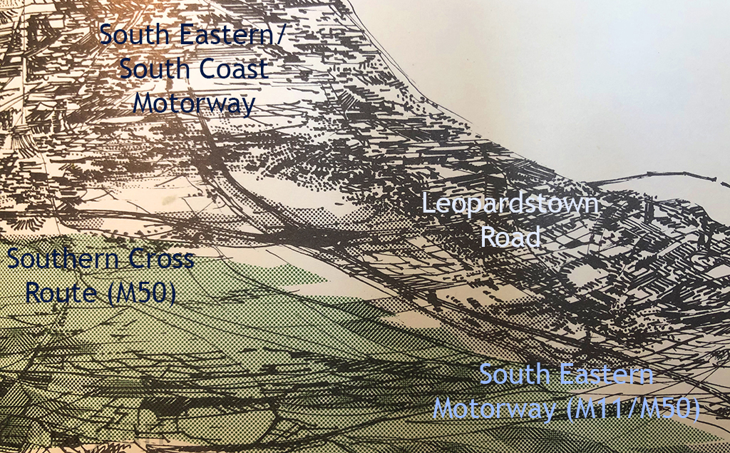
There would have been a junction with the N11 Stillorgan Road. From here, the name of the contract would have changed to South East Motorway, though effectively it was to be the same road.
The South East Motorway would then have run north of Foster Avenue, and though houses have since been built in this area, the route of the road was left clear and can still be made out today. This road would have opened with three lanes (D3M).
Just before Goatstown, the road would have headed south, having an interchange with Mount Anville Road. It would then head due south, along what's now the Drummartin Link Road. In the original plan there would have been a spur from here to Donnybrook - in fact that's where the idea for this road came from - but that spur was soon removed.
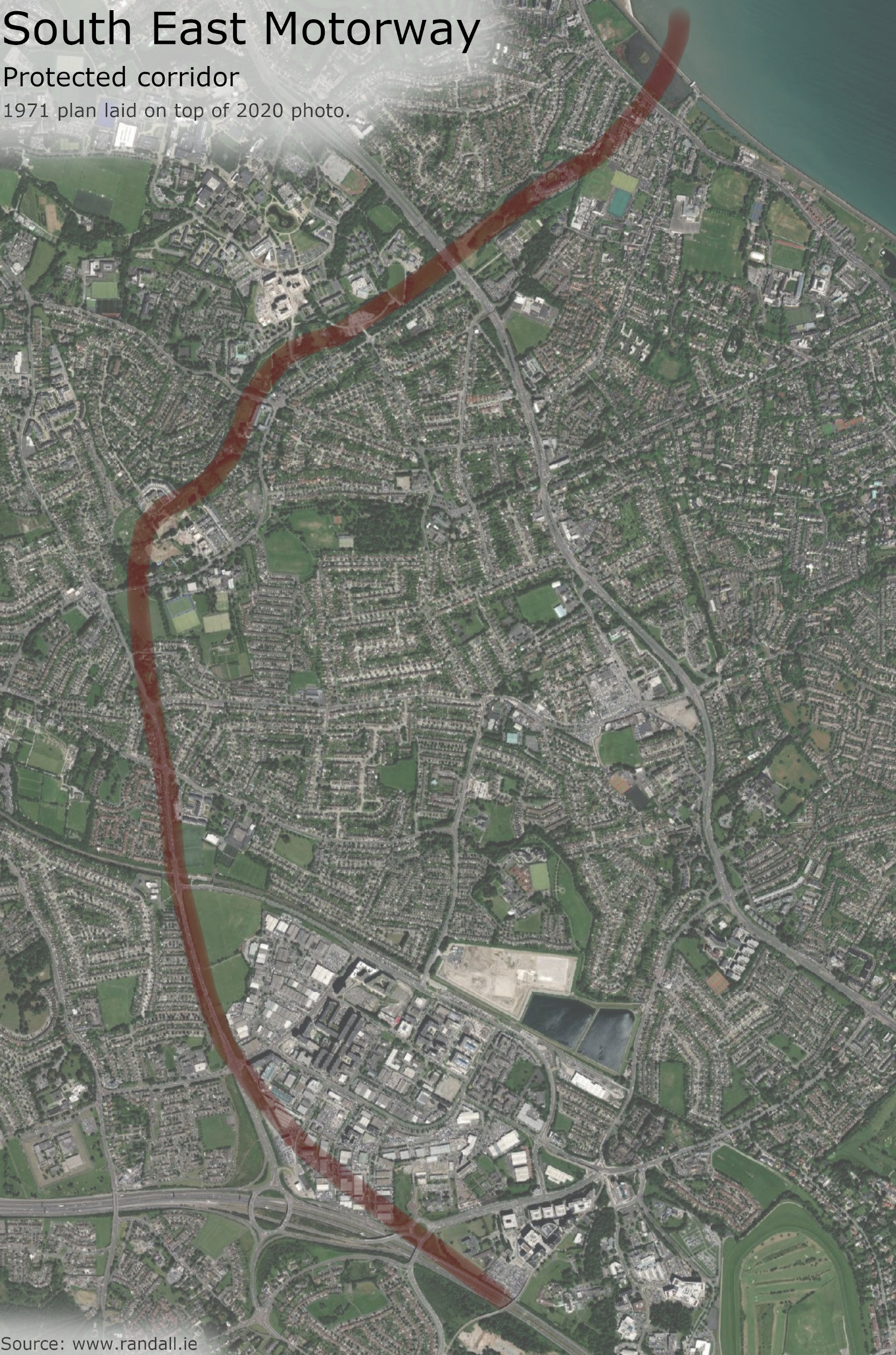
The route of the motorway between Booterstown and Sandyford, laid on top of a 2020 photo, showing how some of the corridor has been protected from develoment (4.03 MB, tap to enlarge)
link to Google Maps
At Sandyford, the South East Motorway would have met the M50 - but the M50 would have ended there. The South East Motorway would then have followed the line of what's now the M50, with the junction at Carrickmines and another at Loughlinstown, where a spur that would have headed up to the N11. Initially this exit was placed closer to Cherrywood; the road itself would have ran further away from Shankill than it does today.
The road would have continued around Bray, coming to an end at the county boundary. This end of the South East Motorway would have had two lanes (D2M), but with space for a third to be added later.
The South Coast Motorway, being effectively an urban relief road, was treated as a very high priority. The section between the Liffey Crossing and Irishtown was postponed only because it was dependent on having other roads to connect to.
The South East Motorway, which would have primarily served new housing estates, was considered to be a relatively low priority.
Based on the 1971 plan, it is reasonable to deduce that the road from Dublin City Centre to Bray would have been numbered as one motorway and that, based on the modern numbering system, that motorway would have been called the M11.
Clearly that wasn't what they were planning in 1991, otherwise they wouldn't have numbered the junctions at Bray 4, 5 and 6. However those numbers match perfectly with the contract we named as the 'South East Motorway': J4 for the spur at Loughlinstown, J3 for Carrickmines, J2 for the M50 at Sandyford and J1 for Goatstown, with the contract ending at Mount Merrion. This is pure speculation, and while it all fits together very nicely, no concrete evidence has emerged.
We will discuss what happened in 1991 in chapter 4. First though, we have a few more roads to tell you about:
Fairview Spur
The Fairview Spur was a very short motorway, which would have started with the other roads at the Liffey Crossing, and then run along the edge of Fairview Park.
It would have ended at Marino Crescent, probably at a set of traffic lights.
In the Dublin Region Plan, this corridor was shown as the start of the Airport Motorway. After that road was moved, a short stub was left behind that simply linked the Liffey Crossing to East Wall Road. It was then decided to extend it towards Marino, preventing all that traffic from being dumped in East Wall, creating a Fairview Bypass.
The next map shows there still being an exit at East Wall Road, but by the end of the study this had been removed.
While it would do a good job relieving Fairview, the spur's job was to funnel traffic to and from the Liffey Crossing. With no crossing, there would be no spur.
Fairview Park, the likely end of the Fairview Spur.
Naas Road
By 1971 the N7 Naas Road between Drimnagh and the county boundary had already been upgraded to dual carriageway, albeit one that wouldn't meet today's standards and had a poor reputation amongst drivers.
The Transportation Study repeatedly mentions replacing the Naas Road with a motorway, but it claims that this decision was made at the last moment. However, this appears to be a misunderstanding.
At one point, the study explains that the plan for the Naas Road is "not necessarily" to create a full motorway, but a "junior expressway". This would be a road that is built to the same standards as a motorway, but without the laws that are applied when a motorway is created.
This appeared to be a pedantic but important legal point. Since the Naas Road already existed, it would be a long legal process to redeclare it a motorway. It would be quicker to just build a whole new road - but a whole new road wasn't needed.
Whatever the Naas Road would have been called, the Transportation Study recommended that junctions be provided at Red Cow, near Kingswood (now N7 J2) for a link road to Tallaght and Clondalkin, and at Saggart (near N7 J4), where the Southern Cross Route would have branched off and cut the corner for people heading towards Bray and Dun Laoghaire.
The whole project was a low priority - the study praised the existing N7, and said it was one of the country's safest roads. It suggested that upgrades be applied "systematically" into the 1990s. The completion of Newlands Cross in 2015 meant this goal has been completed, albeit with a lot more exits than originally envisaged.
Separately, Kildare were planning their own motorway at Naas, which opened in 1983 as Ireland's first motorway. This would later be given junction numbers that allowed for an extension to Red Cow.
The N7 was eventually upgraded to an urban expressway.
M50 - The Western Box
The network of radial motorways described so far would have been held together by a motorway box. The Airport and South Coast motorways mentioned above would have formed the eastern side, while what we now call the M50 would have been the western side.
The route of the Western Box would have been very similar to the M50 we have today, ignoring the section at the Dublin Tunnel which is a product of much more recent history. The Western Box would have been divided into the Northern Cross Route, Western Cross Route and the Southern Cross Route.
The Northern Cross Route was regarded as a low priority, as the land it crossed was mostly still fields at the time. Its purpose was to link up the northern suburbs.
It would have had its junction with the Airport Motorway, and the junction at Ballymun. At Finglas, the junction would have been slightly west of the N2, with link roads heading to the N2, Ongar and to Ashtown on the Northern Spur.
The first plan had the Northern Cross Route (M50) turning south at Kildonan, where it would then end on the Royal Canal Motorway (M4) at Ashtown. This was considered to put too much pressure on the Royal Canal Motorway, so an extra arm of the Northern Cross Route was added, running via Blanchardstown to meet the Western Cross Route. The road to Ashtown was initially kept on as the Northern Spur, but later downgraded from a planned motorway to a planned local road.
There would have been no junction at Blanchardstown, with the next junction being the Royal Canal Motorway at Castleknock.
From here the Western Cross Route took over, and was a high priority because it crossed the Liffey. Its purpose was to allow the three new suburbs to function on their own, without depending on Dublin. When it finally it opened it was branded as the Western Parkway; in planning it was only ever the Western Cross Route.
It would have had its junction with the N4 at Palmerstown, and then another at Clondalkin. The next would be at Red Cow, where there would be the N7 to Kildare and the city centre. The next junction was at Tallaght.
The road was intended to open with two lanes (D2M), but with space to widen it to three and then eventually four lanes (D4M) over the following 20 years. This would involve a second bridge across the Liffey, with space being provided along the embankment.
Then the Western Cross Route would have ended at Ballycullen, where there would be two options. Traffic could join the Southern Cross Route and head west, with junctions at Killindaran and with the N7 at Saggart. Or it could head east.
A sketch shows the roads heading off in four different directions at Sandyford.
The whole of the Southern Cross Route was a low priority, but it would have allowed people coming up from Kildare on the N7 to cut the corner when heading towards Dun Laoghaire as well as supporting the growth of Saggart. The idea for that section stems from the Myles Wright study, which wanted to route the whole N7 Naas Road along this corridor.
From Ballycullen, there would be an extra junction at Edmonstown, plus Ballinteer and Sandyford - where the link road would go on to Deansgrange. The road was going to be designated the absolute urban boundary, with no growth allowed south of this line.
At Sandyford, the Southern Cross Route would have ended, as here it would have met the South East Motorway. Traffic could either head north into the city centre, or south to Wicklow.
Today the M50 doesn't end here. The section between Sandyford and Shankill is right on the line that was reserved for the M11, right down to the layout at what's now the M50/M11 interchange. This history explains two of the bends in the modern M50, at Ballycullen and Sandyford.
The Southern Cross Route deserves one final mention, because considerable comment was made about its landscaping. It would have taken a much more direct route across Marlay Park, offering views of the Dublin Mountains on one side and Dublin City Centre on the other. Its climbs and bends were seen as attractions, and the road would have been landscaped with a wide central barrier that would have rocks and trees. It would be what the Americans call a "parkway".
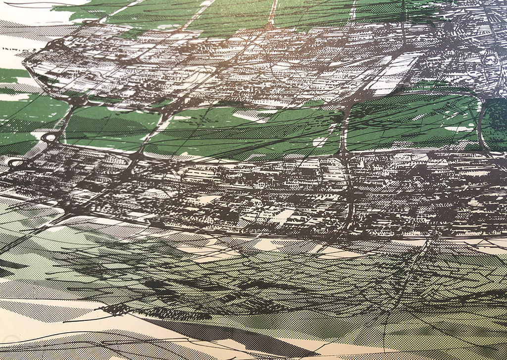
New roads proposed in the Dublin Transportation Study (highest priorities in red),
laid on top of a modern (2020) map (4.97 MB, tap to enlarge)
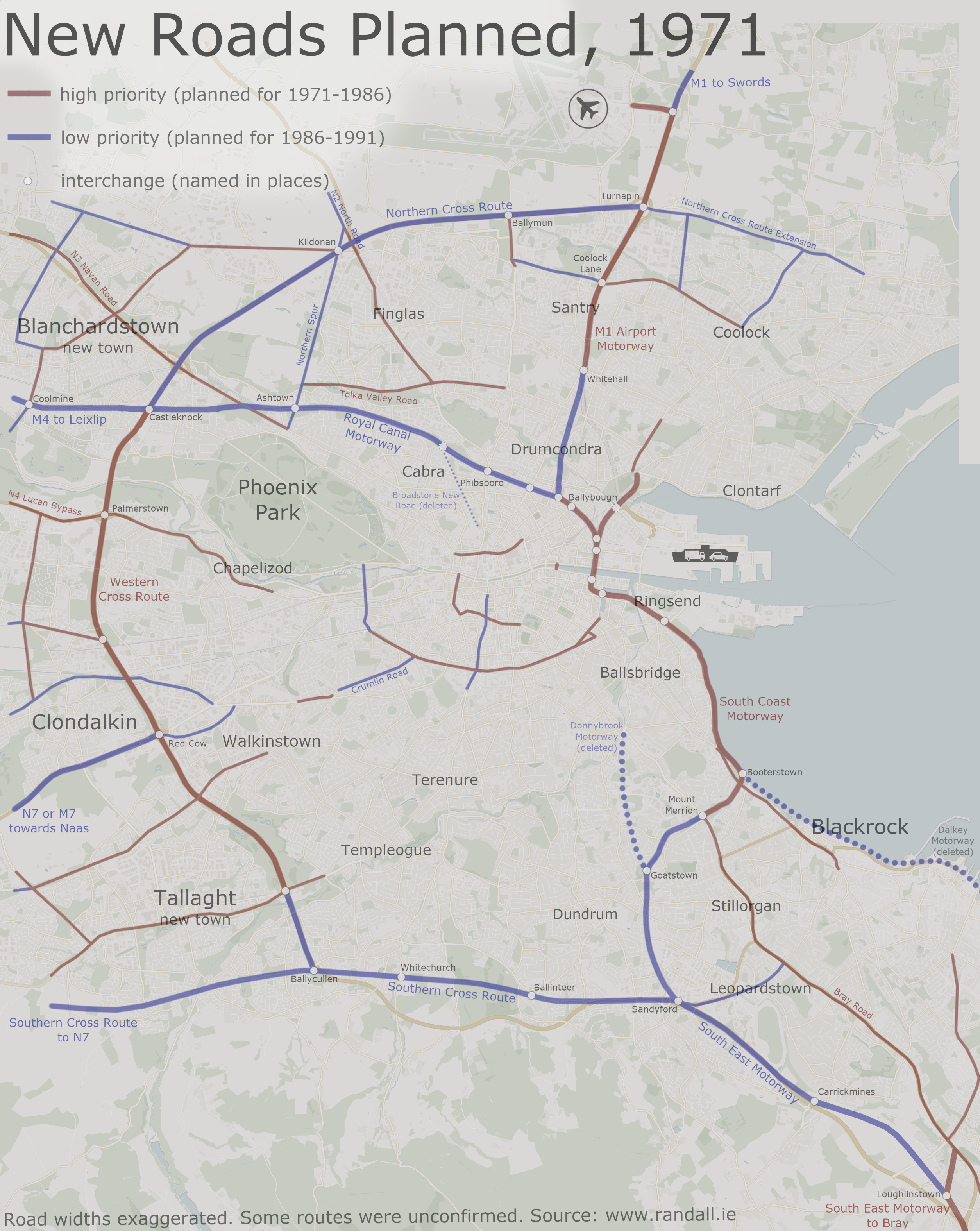
More Roads
The Dublin Transportation Study didn't just deal in motorways, although clearly they were the most remarkable aspect.
It also proposed numerous suburban road improvements, including the urgent construction of the Palmerstown Bypass, Finglas Bypass and Stillorgan Bypass. The Navan Road, R102 orbital road and a new road through Drimnagh were in there too. It also supported improvements to railways, and the creation of high-speed bus corridors.
The final mention goes to the Canal Ring Road. Clearly the nothern section had been replaced by the new Royal Canal Motorway, but attention was needed at the southern section.
Dr Schaechterle's plan of covering the canal with a large dual carriageway had a legal hurdle thrown in its way. In addition, following the backlash, the Corporation distanced themselves from the idea in 1969.
As well as the political problems, the Dublin Transportation Study predicted that a route like this would become too popular with traffic, and would quickly become congested by trying to carry traffic that ought to be on the new motorways.
Instead, the Transportation Study proposed that a residential dual carriageway be built around the Grand Canal, with more attention paid to landscaping. Bravely, they believed that so long as the new road's capacity was kept low, it wouldn't become overwhelemed. But, it stressed, this theory would only work if the motorways were built as planned.
A sketch of people enjoying the environment along the revised Grand Canal Route.
At the western end, the remains of the Grand Canal Road would have met upgraded roads to Islandbridge and Drimnagh. At the eastern end, the road would have ended at Mount Street, where two ramps would have fed into the South Coast Motorway at Grand Canal Dock.
This decision for the Grand Canal was chosen out of three options. A rejected option involved a considerable upgrade, with four diamond interchanges, one "complex" (their word) at Suir Road and four underpasses. This was considered unnecessary and destructive. Other sources claim a long tunnel was looked at.
Where Are All The Trains?
There's no mention of trains in the Dublin Transportation Study. At the time it was written, railways were considered to be redundant in Ireland. Myles Wright used the phrase "popular but unsuccessful".
The only route that was ever highlighted for investment was the line between Howth and Bray, which was soon turned into the DART Rapid Transit route. The rest of Ireland was considered to be too sparsely populated for trains to ever work. Two of Dublin's main stations had just been closed down. Public transport was expected to pay its own way, and this would only work in densely populated areas rather than the low-rise, big-garden suburbia that was proposed for Dublin's commuters.
Buses were well received. Well, they run on roads. There was vague talk about a network of bus-only roads, and coaches would benefit from the new motorways.
Aside from the nice drive along the canal, it is difficult to ignore the American influence of the Dublin Transportation Study. Many of the interchanges, not to mention the very concept of an elevated motorway snaking its way into the city centre, looked like something that would be more at home in California.
Clearly, most of these roads weren't built. We will cover that in chapter 4. They were approved by the Corporation and adopted into their city development plan in 1973. But there was more to be had.