Dublin Traffic Plans
All over the developed world, cities went through a phase where they fell in love - and then usually fell out of love - with the motor car.
This phase was usually an exciting time of optimism and aspiration, and a time where places wanted to change their face beyond all recognition. It rarely worked out well.
Dublin has been shaped by many historic events but one that has had a big impact on the appearance of the city is its failed aspiration to embrace the motoring era.
This is the story of Dublin's three transport plans; how they could have created a very different city; and how you can still see evidence of them today.
This page intends to give planning fans an accurate summary and introduction to what each proposal involved. It doesn't claim to list everything that was proposed. For that, you would need to consult the original plans.
Map links have been provided throughout the text to help anybody who doesn't recognise the street names. Drawings with a blue border will show much more detail when expanded.
The title of this feature was taken without shame from Jay Foreman's fantastic Unfinished London series, which would be of interest to anybody who is interested in urban planning or peculiar council behaviour.
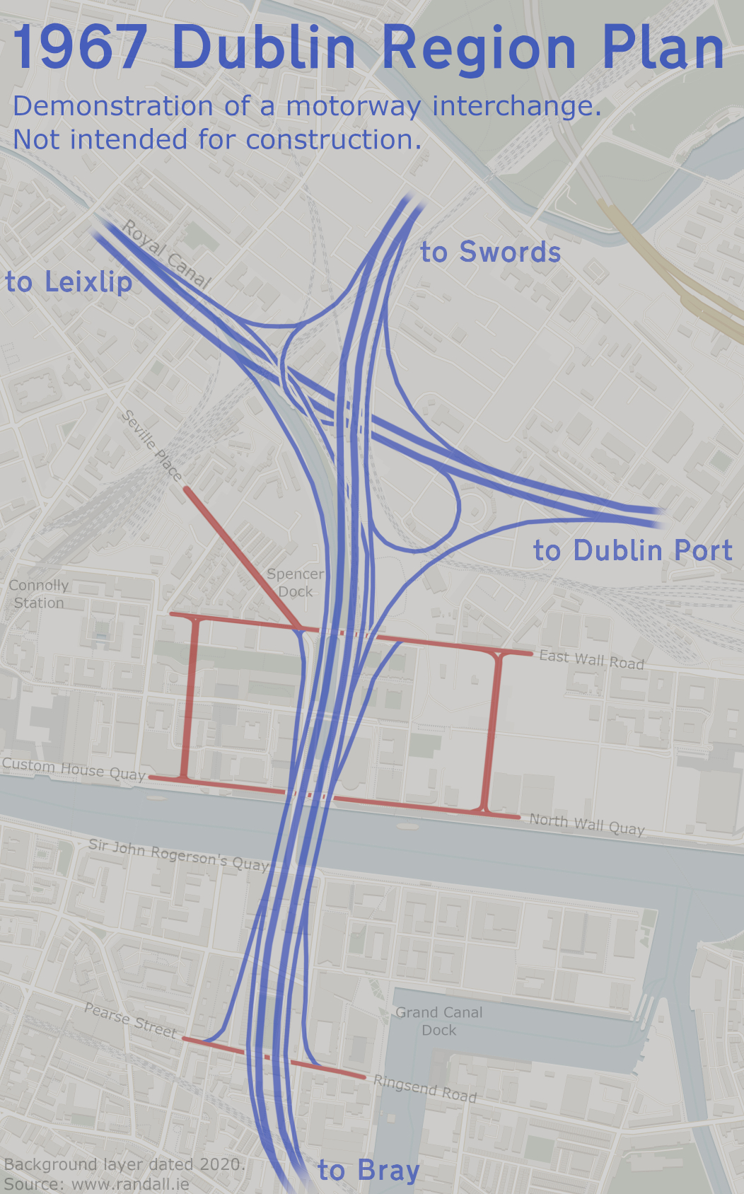
A sample drawing of a motorway interchange. This was produced in 1967 as only a concept, but it is detailed enough for us to envisage how such a layout would fit in today. Tap to open full recreation (1.4 MB)
Contents:
- Chapter 1: First Effort
- Chapter 2: Motorways
- Chapter 3: City Centre
- Chapter 4: Outcome
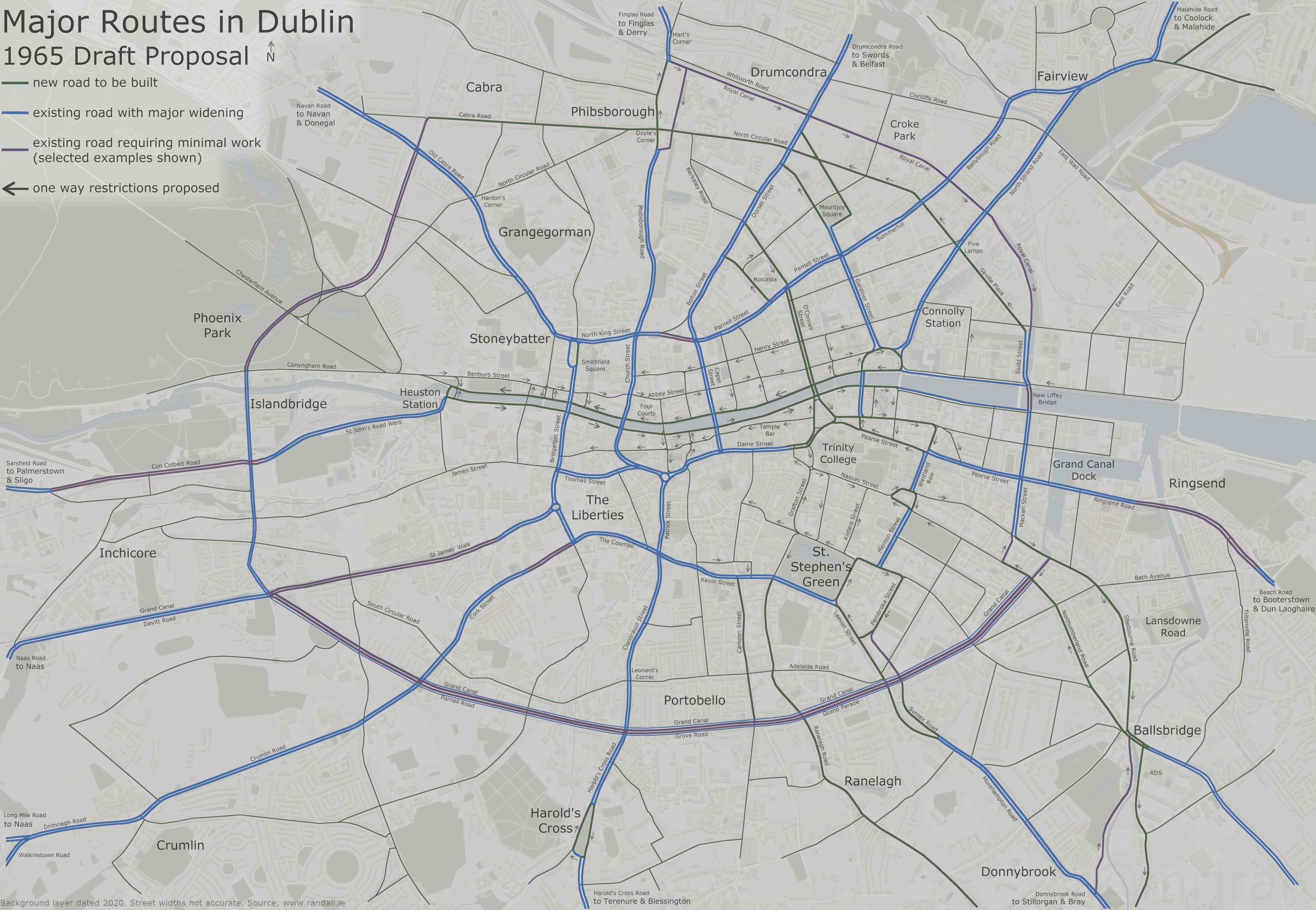
1/4: General Traffic Plan (1965)
At the start of the 1960s, several studies were published looking at the demographics and societal changes in Dublin.
These generally looked at themes such as emmigration and changes to the workplace, with the idea being that this would affect how we structured and designed the city. Nobody had considered traffic.
German civil engineer Dr Karl Schaechterle was commissioned to carry out the first ever study into the city's traffic flow. This consisted of traffic counts on key roads, applying a few rough traffic growth calculations, and then proposing a road network that could cope with that traffic.
This wasn't Dublin's first ever road plan. For example, since the 1940s there had been plans to upgrade the road between Donnybrook and Bray. In 1953, residents of Clanbrassil Street were given official notice that the road was going to be widened. And thirdly, in 1959 a study was carried out into building a "motor road" along the recently-closed railway between Shankill and Harcourt Street.
Overall, progress on projects like those had been slow, often being repeatedly re-examined when it was realised that traffic levels had risen again. Each street was being considered in isolation with no consideration given to where people were actually going. The General Traffic Plan was the first study to seek an understanding of the whole network.
Four possible networks were created and examined, with Proposal 4 providing the most satisfactory results. Although all four were broadly similar, number 4 is the one we'll describe.
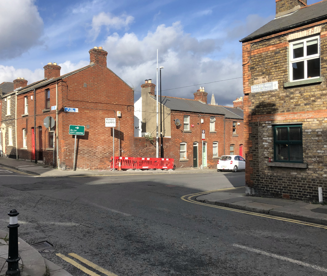
One of the sharp bends at The Coombe (Ardee Street), making this an unsuitable route for heavy traffic. Pictured in 2020, where the strategic road signs are still in place.
Today you would call Dr Schaechterle's recommendations insensitive. Amid the enthusiasm for futurism, no consideration was given to preserving what was there. If it was in the way, it would go.
A map of the proposals is included further down. Most of his suggestions involved widening key roads into the city, but he also included a number of new projects:
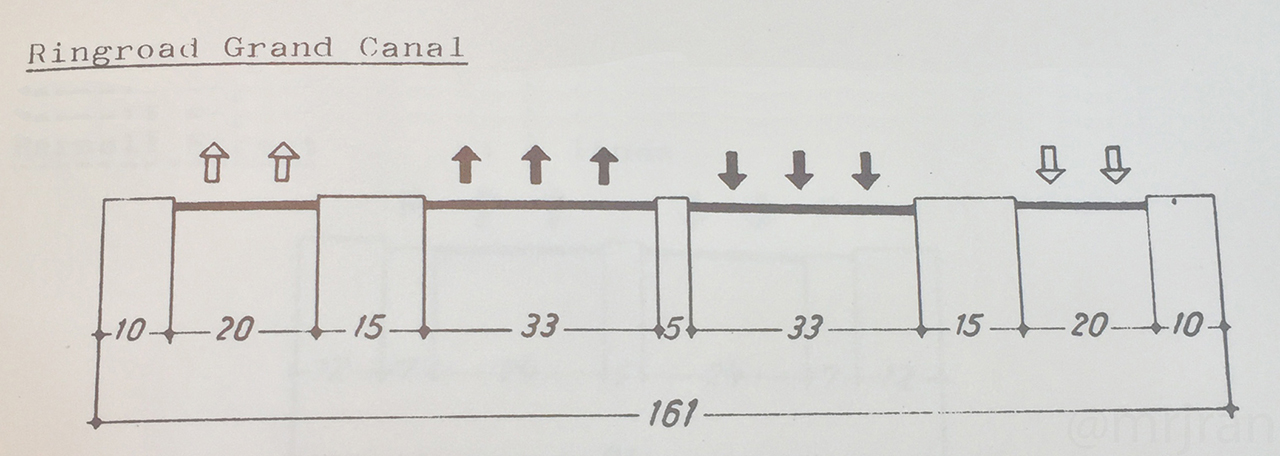
Cross-city traffic would be able to use the Canal Ring Road:
Along the Grand Canal (the southern part of the ring), this would mostly be a three-lane dual carriageway with two local access roads (Q3+2), covering the canal.
It would then follow the existing road past Kilmainham and Islandbridge.
A new road would run in a straight line between Islandbridge and Cabra. This would involve a tunnel under Phoenix Park, and would then follow the railway line.
At Phibsborough, a new road would be built on top of the Royal Canal, carrying eastbound traffic only. Westbound traffic would have the existing North Circular Road to itself.
The two roads would meet by Spencer Dock, and run down to the new Liffey Bridge.
The Liffey Bridge, built roughly where the Samuel Beckett Bridge is today, would be a four-lane dual carriageway (D4) built at ground level.
This Ring Road was considered to be very important to the system, and most parts would have used flyovers to avoid traffic having to stop.
It is important to remember the Grand Canal carried its last working cargo barge in 1960, and the Royal Canal's was in 1955. The attitude was that they were redundant assets, they were quickly falling into disrepair and they were becoming unsightly. So while filling them in may have been bold, it wasn't considered to be an entirely backwards step.
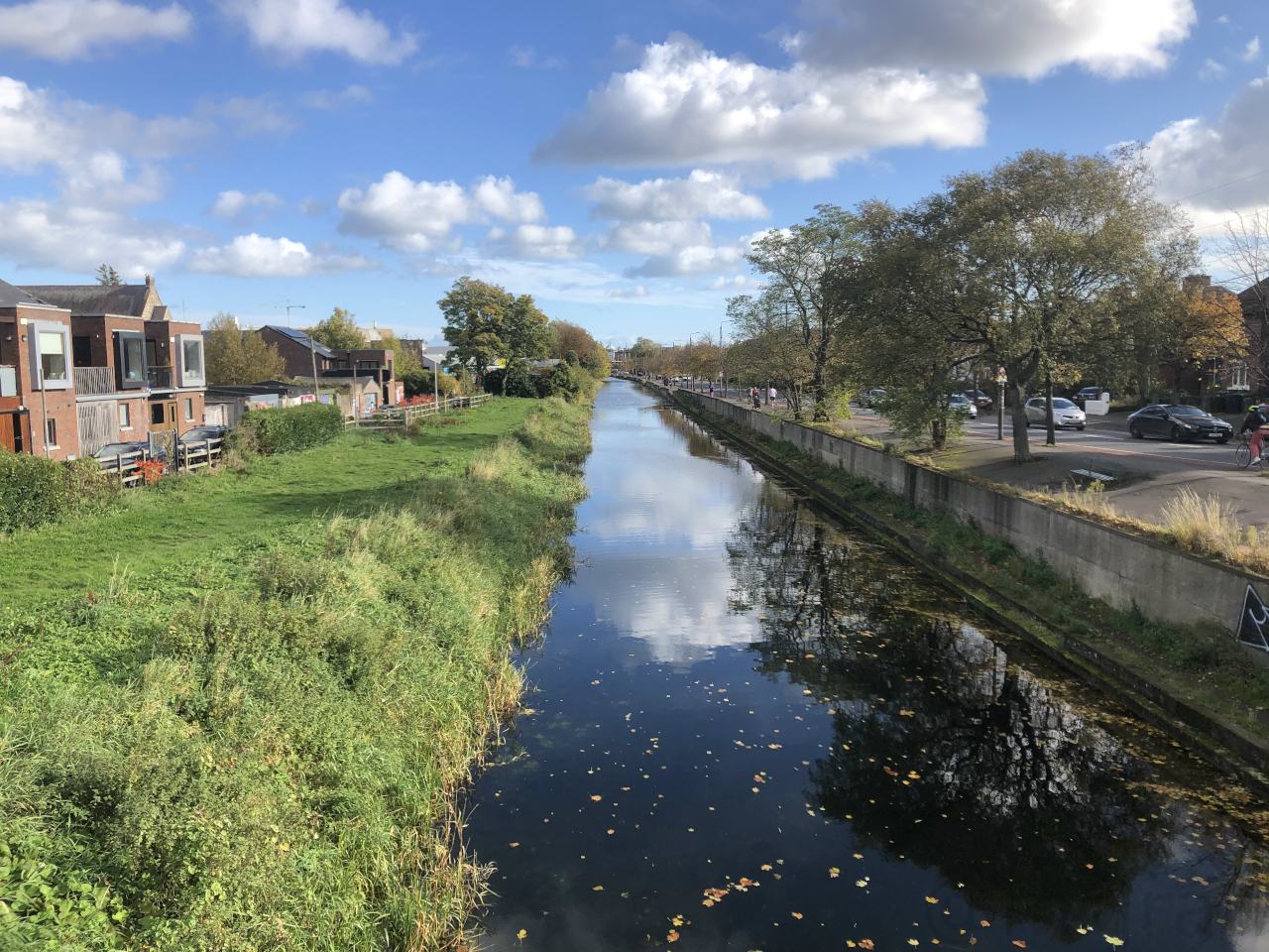
Above: A sketch of the planned arrangement on top of the Grand Canal.
Below: The Grand Canal in 2020, in roughly the same spot. You can see how the two side roads would serve the houses.It wasn't even a new idea. The Grand Canal was still owned by the state transport operator CIÉ, for whom it was a burden that they desperately wanted rid of. Back in 1963, councillors had already put forward the idea of turning the canal into a roadway, but their proposal received a mixed response and hadn't been carried forward.
Away from the canals:
A new road would be built along the former St James arm of the canal route, between Goldenbridge (Davitt Road) and The Liberties. It would have been a three-lane dual carriageway (D3).
A new road would link Clonskeagh and Donnybrook, replacing Beaver Row. Clonskeagh Road would become a major route into the city from the south.
One way systems would have been created in many places, such as Phibsborough (using Royal Canal Bank), Leeson Street (by demolishing the buildings), along the Dodder at Donnybrook (by building a new road along the river), around Baggot Street, around Mountjoy Square, and at Harold's Cross.
Many roads would have been straightened. The main issue was The Liberties, an area which hadn't been touched by the Wide Streets Commission, and as a result access to the city was via the narrow and tight Ardee Street, which had been inappropiately designated road T5A to Limerick. Irishtown was another narrow and winding suburb that was going to be straightened.
Several large roundabouts would have been built, such as outside Christchurch and in the middle of The Liberties.
Fairview Road would have been an interesting one. It would have had 3 lanes on each side, plus 2 extra lanes that would have been reversible depending on the traffic flow (S8).
Butt Bridge would have been widened to a three-lane dual carriageway (D3). Many other bridges would have been widened with a new bridge built alongside.
Parnell Street would have been widened to a two-lane dual carriageway with parking throughout (D2). This was the first time it was suggested that Parnell Street be extended through to North King Street, to prevent the twisty dogleg around Ryder's Row. Such a project was considered to be a "high priority", with Dempseys music shop demolished.
Merrion Square West would have been widened to a three-lane dual carriageway with parking (D3).
Malahide Road would have been widened to a two-lane dual carriageway with parking (D2).
Swords Road and Drumcondra Road would have been widened to a three-lane dual carriageway with parking (D3). This was a phase two priority.
Strand Road would have been widened to a two-lane dual carriageway with parking (D2). This would have been extended along the coast, all the way to Dun Laoghaire.
St John's Road West would be upgraded and extended towards Ballyfermot, to create a new route out of town.
Roads selected for widening in the General Traffic Plan, laid on top of a modern (2020) map (10.87 MB, tap to enlarge)
Specifically, the highest priorities highlighted were as follows. For phase one:
Building a new road between Parnell Street and North King Street.
Widening Church Street and Bridge Street.
Widening the roads between Leeson Street and Cork Street (the southern tangent).
Improving the route between Merrion Road and Butt Bridge.
For phase two, the following roads would have been widened to three-lane dual carriageway:
These days people tend to explain this study by talking about "motorways". At the time, Irish law made no provision for the existence of motorways - there weren't any to write about. While engineers would have known what a motorway was (having seen them in Britain and elsewhere), there was no suggestion that this was what they were aiming for.
Having said that, a short section of the Canal Ring Road (what's now called Parnell Road) would have had wider lanes than the main section, and it would have been lower down than the surrounding roads. It would also have had many flyovers.
However, the study didn't rule out providing some traffic light junctions where a more detailed analaysis shows that it could work. That doesn't fit with what we would call a "motorway".
It is clear that the Grand Canal Route was supposed to be faster than the other roads - but to suggest it was going to be promoted to a whole new category would be pure guesswork.
Going Around In Circles
Dr Schaechterle's broad idea was a "hub and spoke". His top priorities were creating roads that would get people into the city fast.
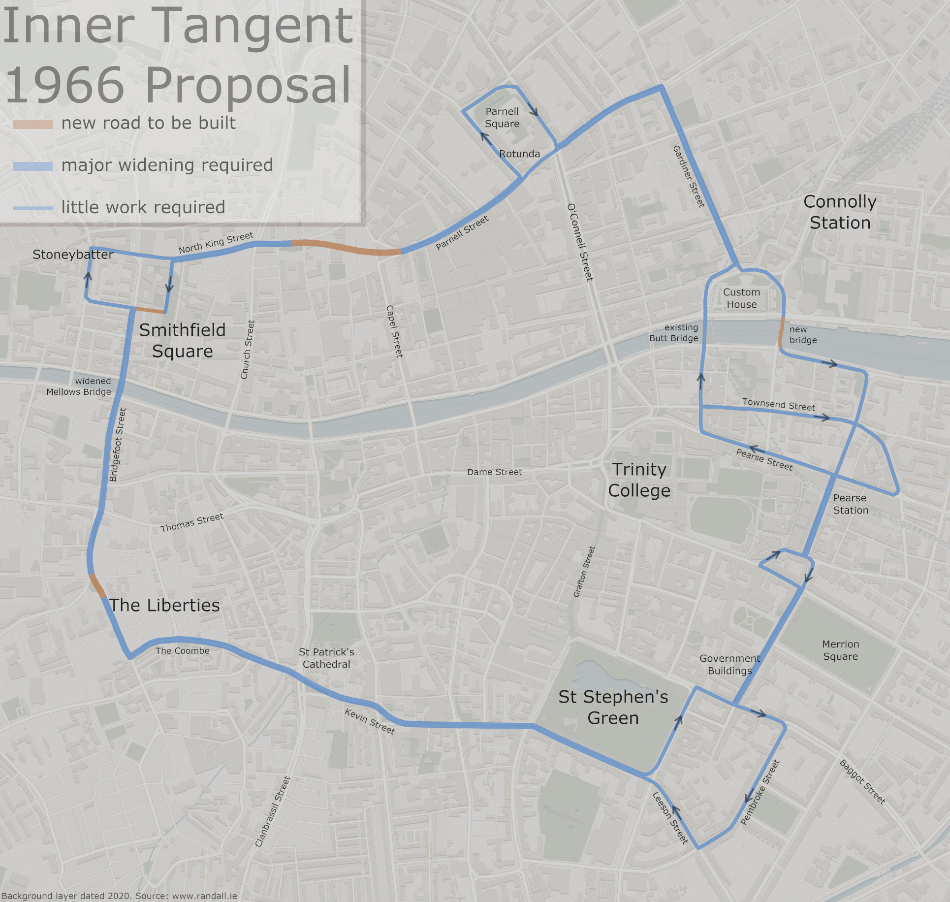
However, he also gave detailed consideration to getting people around the city. He highlighted Parnell Street, Capel Street, Dame Street and O'Connell Street as key routes that should form a box, within which you wouldn't really need to drive.
He also introduced a word which would later become toxic in Dublin: "tangent".
The tangent was a slightly larger box, which would provide another route that avoids the city centre. Initially he wanted to use Steeven's Lane, but joining up with it proved to be too expensive, so a more obvious route along Bridgefoot Street was chosen instead.
The confirmed Inner Tangent route, laid on top of a modern (2020) map (2.69 MB, tap to enlarge)
Dublin Corporation loved the tangent. When they adopted Dr Schaechterle's proposals and made them city policy, the tangent was one of their highest priorities.
The Inner Tangent would technically have been the middle of three rings, with the Canal Ring Road described above serving as an outer ring and taking a lot of the work.
Shortlived Vision
Initially, the media's coverage of the new proposals was focused on the new Liffey Bridge, and it was generally positive. The route upgrades made it into the Corporation's development plan without commotion.
It wasn't long before the reality of losing the canals set in.
In 1967 the Grand Canal was supposed to be legally closed but, following a campaign from the public and the Inland Waterways Association, the closure authorisation came with a condition that the canal needed to be restored as an amenity.
This would ultimately end any chance of the canal being filled in, although certain corners would keep pushing for it.
It is hard to find a clear example of Dr Schaechterle's proposals in action, as most of them would end up passing through several more studies before being built. Church Street Upper, where the flats were built, appears to be one example of Dr Schaechterle's plans being adopted quickly.
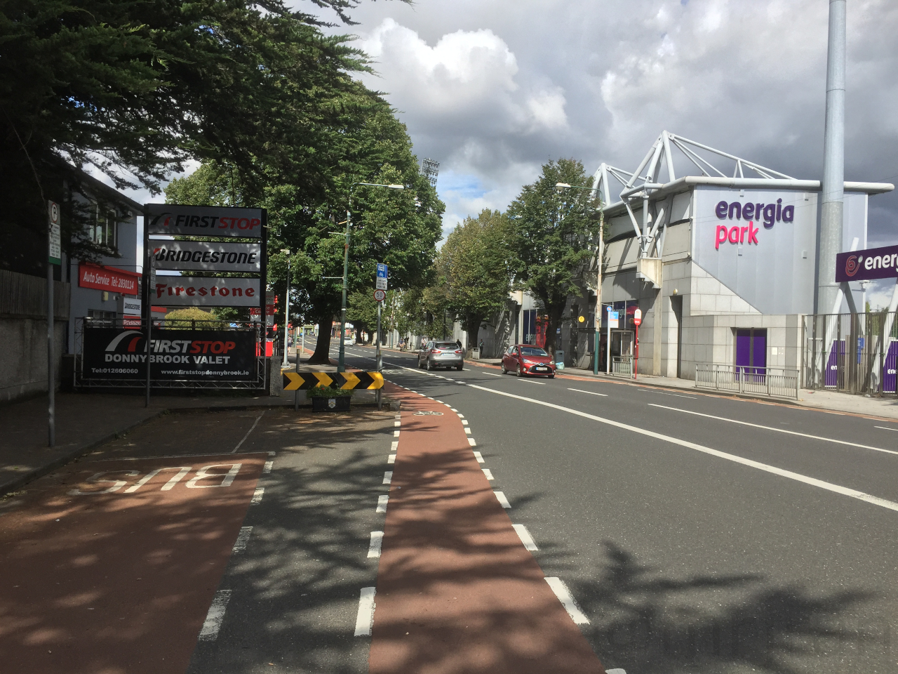
Perhaps the best one to look at is Donnybrook, where the dual carriageway Stillorgan Road makes it over the bridge and then just gives up. The job was only ever half done.
The other thing to look at here is the industrial units on the left. Buildings like this are easy to move, meaning they are often found where demolition was expected. A short extension of the widened road was still planned as recently as 1980.
The sudden road narrowing at Donnybrook, showing that somebody thought the dual carriageway would be going further into town.
Dr Schaechterle's study was the first of its kind in Dublin, and it was flawed. It considered the existing city in isolation, and didn't take account for how it would expand.
Part of the problem was that the study was being conducted on a very tight budget, such was the state of public funding in Ireland at the time. In Britain, a study like this cost on average 40p per resident. Dublin's cost 6p per resident.
A few years later, Myles Wright's 1967 Dublin Region Plan painted a picture of a city that would be expanding outwards, with long-distance commuting and a significant rise in the county's population. Wright took Schaechterle's work and added a number of potential motorways that would link up these new suburban areas.
Mixed in with a bit of theory about urban road design, the Dublin Region Plan envisaged Dublin being boxed in by a network of motorways, with an additional, dense grid of fast-flowing roads through suburbia that we would now call Tallaght and Clondalkin. The western side of the box would extend from Meath to Kildare, forming the 'outer orbital' which would go on to be discussed so much.
While interesting, the detail of the Dublin Region Plan was only crayons on a map. It highlighted areas that should be studied in more detail. So we pick up the story with what happened next.